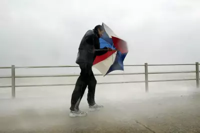
Britain is braced for a day of severe disruption as forecasters warn of violent thunderstorms and potential flooding across multiple regions. A band of low pressure sweeping eastwards is set to bring torrential rain, hail, and gusts of up to 60mph, prompting a significant number of official warnings.
Widespread Disruption from Storms and Gales
Meteorologists at Netweather have issued a thunderstorm alert, with the most intense activity expected this morning across Ceredigion in west Wales and parts of south Wales. The Southwest of England is also on high alert. The Met Office has cautioned that persistent bands of showers will be heavy, with a risk of thunder.
The ground in many areas is already saturated from previous rainfall, meaning any additional downpours could quickly lead to surface water flooding and difficult travel conditions. Gale-force winds may reach 60mph in parts of Devon and south Wales this morning.
Full List of Active Flood Warnings and Alerts
As of today, authorities have issued numerous warnings. There are six flood warnings across Wales, alongside 26 less severe flood alerts. In Scotland, the Scottish Environment Protection Agency has activated eight flood warnings. England faces a substantial list, with key warnings including:
- North Cornwall coast from Lands End to Chapel Porth
- River Severn at Sandhurst and Maisemore
- Plymouth Sound, Wembury Bay and tidal estuaries
- River Axe from Winsham to Axmouth
- Somerset coast at Clevedon seafront
The band of low pressure will move northeast through the day, bringing stormy conditions to Lancashire and Greater Manchester by late afternoon, before drizzle moves over Yorkshire.
Risk of Isolated Tornadoes and Ongoing Threats
The Netweather storm alert highlights the risk of hail, gusty winds, and torrential rain leading to localised flooding. It also states an isolated tornado cannot be ruled out, particularly towards coastal areas of southern England. This risk is due to strong buoyancy over the English Channel combining with forecasted low-level wind shear, which could cause storm updrafts to rotate.
While temperatures will remain mild, the windy conditions are expected to persist into the early part of next week, prolonging the risk of disruption. Emergency services are likely to be on standby for potential rescue operations as driving conditions become treacherous.
Residents in affected areas are urged to check the latest advice from the Environment Agency and Met Office, avoid travelling through floodwater, and secure loose outdoor items due to the high winds.


