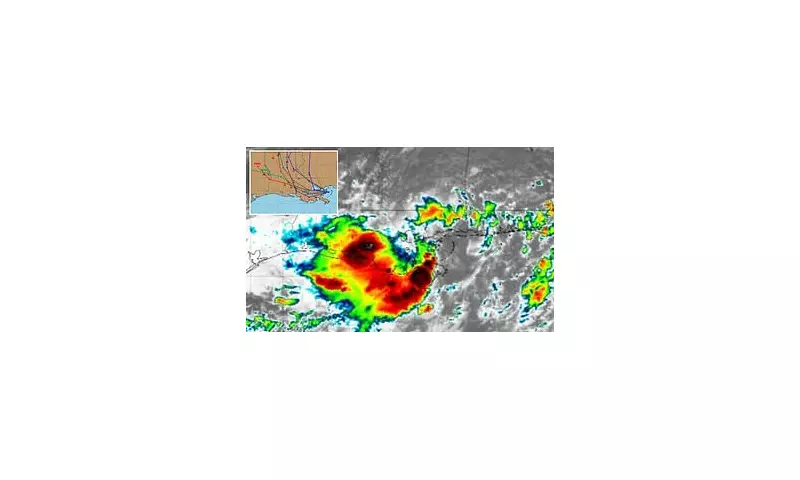
A massive tropical disturbance is gaining strength in the Atlantic, sparking concerns among meteorologists and Caribbean residents alike. The latest spaghetti models - computer simulations used to predict storm paths - show a concerning spread of potential trajectories, indicating high uncertainty about where this weather system might strike hardest.
Storm Intensification Raises Alarms
Weather experts report the system is rapidly organizing, with sustained winds increasing by the hour. Satellite imagery reveals a well-defined circulation pattern, one of the key indicators of a developing tropical storm. The National Hurricane Center is monitoring the situation closely, with updates expected every six hours.
Potential Impact Zones
Current projections suggest several possible scenarios:

- Direct hit on the Leeward Islands within 48 hours
- Gradual turn northward, skirting Puerto Rico
- Continued westward movement toward Hispaniola
Coastal communities across the region are advised to review emergency plans and monitor local advisories. The storm's unpredictable nature makes precise landfall predictions difficult at this stage.
Preparations Underway
Emergency services in vulnerable areas have begun precautionary measures:
- Stockpiling sandbags in low-lying regions
- Testing emergency communication systems
- Identifying potential evacuation routes
Tourist resorts are implementing contingency plans, with some offering early check-out options for visitors wishing to leave before potential airport disruptions.
Historical Context
This developing storm follows an unusually active tropical season in the Atlantic basin. Meteorologists note that sea surface temperatures remain well above average for this time of year, providing ideal conditions for storm intensification. Climate scientists suggest this pattern may become more common due to global warming trends.
The next 24-36 hours will be critical in determining the storm's ultimate strength and path. Residents throughout the Caribbean and along the southeastern U.S. coast should stay informed through official weather channels.