
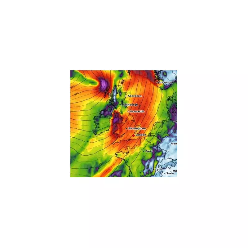
The ghost of Hurricane Melissa is preparing to unleash its fury on British shores, with forecasters warning of potential travel chaos and dangerous conditions as the storm's remnants sweep across the country.
Gale-force winds reaching up to 70mph are expected to batter coastal regions, while heavy downpours threaten to trigger flooding in vulnerable areas. The Met Office has issued severe weather alerts as the tropical system makes its dramatic transition across the Atlantic.
When Will the Storm Hit?
Weather experts predict the deteriorating conditions will begin their assault on Tuesday, building throughout the day and reaching their peak intensity by Wednesday. The timing couldn't be worse for commuters and transport networks already grappling with autumn conditions.

Meteorologist Liam Dutton explained the unusual phenomenon: "While hurricanes typically lose their tropical characteristics when moving over cooler North Atlantic waters, their remnants can still pack a serious punch. Melissa's energy is reforming into a deep area of low pressure that will drive these severe conditions."
Regions Most at Risk
Northern Ireland and western Scotland are expected to bear the initial brunt of the weather system, but the impacts will be felt nationwide. The Met Office has highlighted particular concerns for:
- Coastal communities facing dangerous wave conditions
- Western hills and mountains receiving the heaviest rainfall
- Transport networks vulnerable to high winds
- Urban areas with poor drainage facing flood risks
Travel Warnings Issued
Transport authorities are urging travellers to prepare for significant disruption. Rail services may face speed restrictions, while ferry crossings could be cancelled or delayed due to dangerous sea conditions.
Road users, particularly those driving high-sided vehicles, are being advised to exercise extreme caution as sudden gusts could create hazardous driving conditions on exposed routes and bridges.
The Environment Agency has placed teams on standby, ready to respond to potential flooding incidents as the ground, already saturated from recent rainfall, may struggle to absorb the deluge.
Longer-Term Outlook
While the peak intensity is expected mid-week, unsettled conditions are forecast to persist throughout much of the week, with further bands of rain and strong winds likely to follow in Melissa's wake.
Weather experts note that while such autumnal storms are not uncommon, the specific influence of hurricane remnants adds an extra element of unpredictability to the forecast, making this weather event particularly noteworthy.


