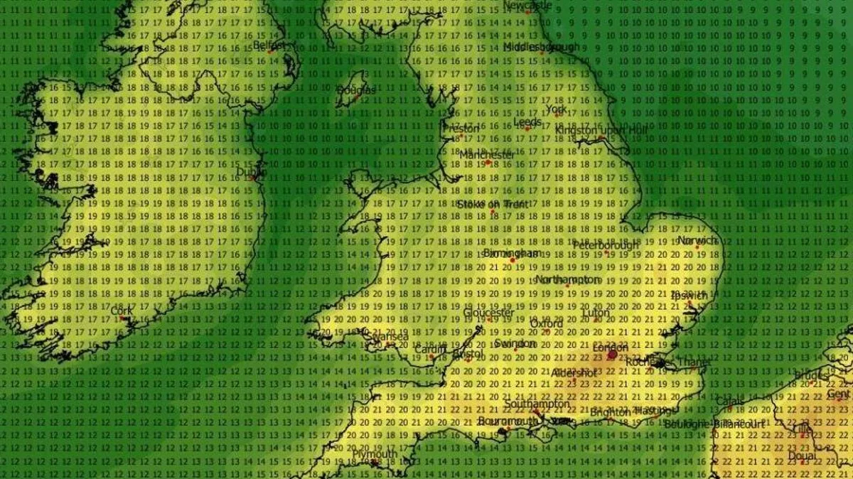
UK Weather Maps Forecast 23C Heatwave for 26 Counties by Late April
UK Weather Maps Forecast 23C Heatwave for 26 Counties

UK Weather Maps Forecast 23C Heatwave for 26 Counties by Late April

New weather forecasting maps have revealed that the United Kingdom could experience a substantial warm spell in less than two weeks, with temperatures potentially climbing as high as 23 degrees Celsius. According to the latest data from the ECMWF weather model, up to 26 counties across the nation are set to be impacted by this surge in heat, marking a notable shift in spring conditions.

Peak Temperatures Expected in Southern and Eastern Regions

The ECMWF model indicates that the highest temperatures will be concentrated in the south-east of England and along the south coast, peaking around 6pm on April 29. Areas such as East Anglia, the Midlands, and parts of Wales are also anticipated to enjoy warm conditions during this period. Further north, temperatures are forecast to remain mild, with highs of 18C expected in Northern Ireland and southern Scotland, and 16C in the Scottish Highlands.

The following 28 counties are projected to see temperatures of 20C or higher on April 29:

Wide Pickt banner — collaborative shopping lists app for Telegram, phone mockup with grocery list
  • Scotland
  • Pembrokeshire
  • Carmarthenshire
  • Glamorgan
  • Staffordshire
  • Warwickshire
  • Worcestershire
  • Gloucestershire
  • Cornwall
  • Devon
  • Somerset
  • Dorset
  • Wiltshire
  • Berkshire
  • Oxfordshire
  • Hampshire
  • Sussex
  • Surrey
  • Kent
  • Middlesex
  • Essex
  • Hertfordshire
  • Buckinghamshire
  • Bedfordshire
  • Cambridgeshire
  • Norfolk
  • Suffolk

Met Office Issues Cautions Amid Warm Predictions

Despite the promising forecasts for a heat surge, the Met Office has issued a cautionary note, warning that parts of the country could still experience cold air and wintry showers. In its outlook for April 22 to May 1, the agency stated that high pressure is likely to remain centred to the north or northwest of the UK, leading to generally dry weather. However, Atlantic frontal zones may bring rain and breezy conditions to the southwest early in the period.

The latter part of April may also see cold air sweep south across much or all of the UK for a time, bringing potential for wintry showers in the north and east and more widespread overnight frost. Any cold spell looks fairly likely to be short-lived before somewhat milder conditions become re-established.

Long-Term Forecast for Early May

Looking ahead to the start of May, from May 2 to May 18, the Met Office predicts that slowly evolving weather patterns will continue. High pressure is expected to be located to the north or northwest of the country, with low pressure closer to southern areas. This setup suggests that northern and western regions will likely remain drier, while southern and eastern parts may see more rain or showers.

Overall, temperatures are projected to be close to or slightly above average, though there is scope for chilly nights with late-season frost, particularly in northern areas. This mixed forecast highlights the variability of UK spring weather, even as maps point to a significant warm spell in late April.

Pickt after-article banner — collaborative shopping lists app with family illustration