


Entertainment

Triple M Ranks Hottest State of Origin Players of All Time
Triple M ranks the most attractive State of Origin players ever, with Craig Wing on Mount Rushmore. No Queenslanders make the list, sparking debate.


Politics

Former SNP Minister Calls for Independent Inquiry into Party Finances
Former SNP cabinet secretary Alex Neil has called for an independent investigation into the party's finances after ex-chief executive Peter Murrell admitted embezzling over £400,000.


Sports

Michael O'Neill signs new long-term Northern Ireland deal until 2032
Michael O'Neill has signed a new contract to remain Northern Ireland manager until 2032, turning down an offer from Blackburn Rovers. He will lead the squad in upcoming friendlies.


Crime

Girl, 11, Nearly Blinded by Exploding Tesco Toy in Viral Trend
An 11-year-old girl was rushed to hospital after a squishy cube bought from Tesco exploded in her face during a dangerous social media trend. She may need skin grafts.


Health


Environment

New Octopus Species Found Near Galapagos
A new deep-sea octopus species, Microeledone galapagensis, has been confirmed from a specimen discovered off the Galapagos Islands in 2015 using CT scans.

UK Heatwave Breaks Night-Time Temp Record Third Day
The Met Office reports the highest daily minimum temperature in May has been broken for a third consecutive night, with Camborne, Cornwall recording 21.4°C.

Alan Titchmarsh: Which Plants to Water or Sacrifice in Heatwave
Gardening expert Alan Titchmarsh advises on prioritizing watering during drought, suggesting which plants can be left without water and how to conserve resources.
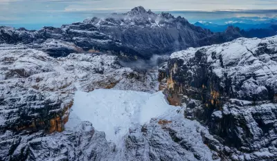
Last Glaciers in Oceania Mapped Before Disappearance
Project Pressure creates the first 3D model of Puncak Jaya's glaciers in Indonesia, which have shrunk by 95% since 2002 due to climate change.

Indonesia's Eternity Glaciers Nearly Gone: 95% Ice Loss
An expedition to Indonesia's Puncak Jaya glaciers found 95% ice loss since 2002, with scientists racing to document the last tropical glaciers in Oceania before they vanish.
Tuesday Test: Can You Answer These UK Sports Questions?
Test your knowledge of British sports with our Tuesday quiz featuring 100 questions about football, cricket, and rugby. Perfect for sports enthusiasts and trivia lovers.
