
A massive and dangerous winter storm is currently sweeping across the United States, delivering feet of snow, widespread blizzard warnings, and perilous travel conditions to millions of residents throughout the western and central regions. The National Weather Service (NWS) has escalated warnings, urging extreme caution as this significant weather event unfolds.
Widespread Warnings and Severe Impacts
The NWS has issued winter storm warnings across a vast expanse, including California, Oregon, Nevada, Arizona, Colorado, Utah, North Dakota, Minnesota, Michigan, and Alaska. Officials are strongly advising residents to avoid unnecessary travel due to the high probability of whiteout conditions that could strand vehicles and create life-threatening situations. More severe blizzard warnings have been activated for Montana, South Dakota, and Minnesota, where wind gusts reaching up to 60 mph are expected to combine with several inches of snow, rendering roads impassable for all but emergency vehicles.
Record Snowfall Projections
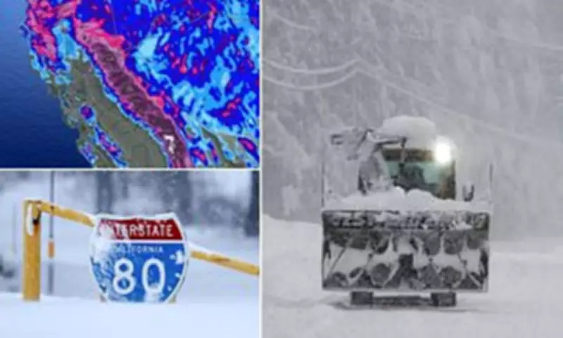
The storm is predicted to be particularly severe in the Rockies and Southwest, with numerous states forecast to receive over a foot of snow accumulation by Friday. Eastern California is anticipated to bear the brunt of the storm, with the Sierra-Nevada Mountains projected to receive an astonishing over five feet of snow. Parts of Oregon, Nevada, Arizona, Colorado, and Utah are expected to see over ten inches, with higher elevations in these states potentially accumulating two to three feet.

AccuWeather Chief On-Air Meteorologist Bernie Rayno provided a staggering long-term forecast, stating: 'When this pattern finally wraps up late next week, parts of the Sierra Nevada will end up with 12-16 feet of snow.' Winter weather advisories have also been issued in Idaho, New Mexico, Wisconsin, Wyoming, and Washington state, indicating the storm's extensive reach.
Millions Affected and Avalanche Dangers
Overall, this widespread winter event could impact up to 100 million Americans, with conditions varying from ice and rain in the Midwest to extremely powerful winds mixing with snow, capable of knocking down trees and power lines in the Northern Plains. Meteorologists expect the most intense snowfall to occur throughout Wednesday, but dangerous conditions are likely to persist throughout the week.
AccuWeather Meteorologist Alyssa Glenny highlighted additional risks, noting: 'Along with the obvious problems from heavy rates of snow will be the potential for avalanches through the passes and in the high country.' This warning follows an incident where at least nine skiers went missing after an avalanche trapped a large group near Lake Tahoe on Tuesday. Further avalanche warnings have been issued for California, Utah, and Colorado due to rapidly accumulating snow, weak snowpack layers, and near hurricane-force winds causing drifting.
Specific Regional Forecasts
Outside of California, parts of Nevada could see more than three feet of snow at higher elevations near the Sierra Nevada. Northern Arizona is projected to receive up to 10 inches of snow, accompanied by wind gusts up to 65 mph, with an additional three to nine inches possible on Thursday and Friday.
Colorado may see between four inches and one foot of snow, with whiteout conditions likely as winds could reach 70 mph—just under Category 1 hurricane strength. North Dakota, Minnesota, and Michigan could experience between three and 15 inches of snow through Thursday afternoon, with severe wind gusts of 35 to 55 mph making local travel hazardous.
Critical Safety Advice from Authorities
The NWS has issued urgent safety guidance for those in the storm's path. For anyone who must travel, it is essential to keep an extra flashlight, food, and water in the vehicle in case of emergencies, accidents, or becoming stranded. Drivers are advised to drive as slowly as possible in snowy conditions and inform someone of their route before departure.

If stranded during blizzard conditions, it is crucial to stay in the vehicle, run the engine periodically for heat while conserving fuel, and avoid venturing out into whiteouts. For those outdoors, dressing in layers, covering all skin, and watching for signs of hypothermia and frostbite—such as shivering, confusion, or numb skin—is vital. The NWS reiterates that the safest course is to stay indoors and travel only if absolutely necessary as road conditions deteriorate rapidly.


