
UK Snow Maps Reveal 24-Hour Blizzard Will Bring 20 Inches as Cities Buried
Snow could hit several major cities next week as weather maps suggest as much as 20 inches could settle on the ground following blizzards lasting 24 hours.
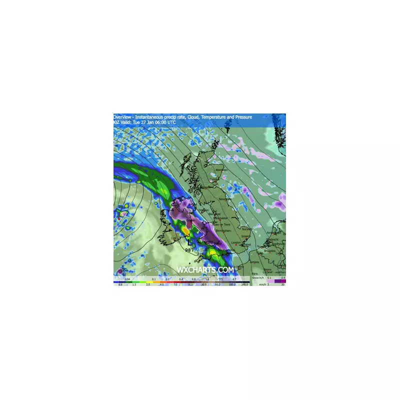
The latest weather maps show a 24-hour blizzard will bring 20 inches of snow to the UK, with several cities set to be buried. While this week is set to be rainy and windy, snow is expected to hit the country next week.
Met Office Long-Range Forecast Details
The Met Office's long-range forecast from January 26 to February 4 says some snow is likely across hills in Scotland and northern England. However, forecasters said snow could also extend to other areas. Now, the ECMWF weather model appears to confirm the predictions, showing snowfall hitting areas including Northern Ireland and Wales from the early hours of January 27.

By midday, snow will have intensified and extended to the Midlands, parts of southern England and Scotland too. Later in the day, there will be further precipitation as flurries will cover most of the country.
Heaviest Snow Accumulations Expected
Snow could continue falling overnight, as maps show the areas with the greatest snow accumulations will be northern Scotland and Wales. The Met Office's long-range forecast says: "Weather systems moving in from the Atlantic will continue to attempt to push in from the west, but tending to stall in the vicinity of the UK as they encounter high pressure to the north and northeast."
"As a result, further spells of rain or showers are likely at times. These may be heavy and persistent, especially in the south and west, with the best of any drier interludes in the far north and northeast."
"Whilst mild conditions are expected to encroach into the south and southwest at times, it is likely to turn somewhat colder through this period, bringing the risk of some snow, most likely across hills in Scotland and northern England, but perhaps extending to other areas with time."
Further Snow Expected in February
Further snow is expected to hit in February, according to the latest Met Office predictions. The long-range forecast from February 5 to February 19 says: "A similar theme is expected to continue as Atlantic frontal systems attempt to push eastwards at times."
"As the jet stream is slightly further south than normal, the wettest conditions are more likely in central and southern areas. North and northwestern parts of the UK are most likely to be drier than normal."
"Whilst mild incursions of wet and windy weather are favoured at times in the south and west, colder conditions in the north and northeast will bring associated wintry hazards where any precipitation attempts to spread in, especially on hills."
Current Weather Warnings in Place
This week, the Met Office issued an amber warning as heavy rain is likely to bring disruption across parts of Scotland. Met Office chief forecaster Dan Harris said: "Rain will turn increasingly persistent and heavy late on Wednesday and through much of Thursday for parts of Scotland, which has resulted in amber and yellow warnings for rain being issued. Within the amber warning area, some areas of high ground exposed to the strong southeasterly wind are likely to see in excess of 100 mm of rain, whilst 50-80 mm is more probable for many places within the broader yellow warning."
"This is expected to lead to flooding in some places, with some rivers taking longer to respond to the rainfall and could lead to ongoing impacts through Thursday."


