Advanced weather modelling maps from the GFS system indicate the United Kingdom could experience its hottest day on record within days, with temperatures potentially reaching 41C. This comes after the country already broke the record for the hottest June day on three consecutive days, culminating in 37.3C on Friday.
The current UK temperature record stands at 40.3C, recorded during the July 2022 heatwave. The GFS model now suggests that multiple days in early July could surpass that mark, with 18 counties in England projected to hit 40C or higher.
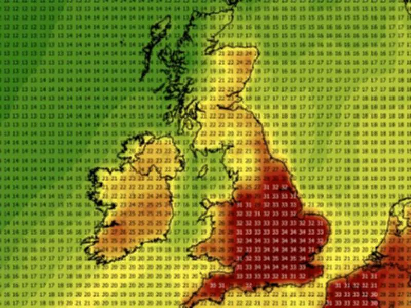
Timeline of Projected Temperatures
According to the GFS data, the heatwave is expected to begin on July 8, when temperatures could reach 35C in the south-east. Central and southern England may see 30C or more, with highs of 33C extending as far north as Yorkshire.

On July 9, southern England could see 37C, while parts of South Wales may reach 32C. By July 10, western and southern England could experience 40C, with widespread highs of 37C to 39C across central and southern areas.
July 11 is projected to be the warmest day, with the GFS model showing possible temperature maximums of 41C in western England. Swathes of the country from Yorkshire down to London could rise as high as 40C.
Conditions are expected to cool slightly thereafter, with July 12 bringing maximum highs of 38C, primarily in the south-east, and July 13 seeing 37C as the top temperature.
Counties at Risk of 40C or More
The GFS weather model maps show 18 English counties that could rise to 40C or more. These include: Yorkshire, Nottinghamshire, Lincolnshire, Leicestershire, Derbyshire, Northamptonshire, Lancashire, Cheshire, Shropshire, Bedfordshire, Hertfordshire, Herefordshire, Worcestershire, Warwickshire, Oxfordshire, Buckinghamshire, Berkshire, and Surrey.
These temperatures would almost certainly constitute an official heatwave, which is declared when an area records temperatures over the heatwave threshold for three consecutive days. The threshold varies from 25C to 28C depending on the county.
Met Office Outlook
The Met Office has indicated a "greater than normal chance" of more hot weather in July. Their forecast for July 12 to 26 states: "High pressure is looking slightly more likely than low pressure during the early part of this period, meaning a greater chance of settled and drier than average conditions."
The forecast adds: "Outbreaks of rain and stronger winds are possible at times, these more likely further north. As normal for the time of year, there is still a chance of some heavy and thundery showers which may interrupt any warm and settled weather."
Towards the end of July, the Met Office notes: "There is no reliable signal for preferring any one weather pattern over another. However, temperatures are likely to be above normal on the whole, with a greater than normal chance of hot conditions developing at times."
Temperature anomaly maps for the period show the UK covered in areas of deep red and black, indicating temperatures well above the seasonal average.