New York City experienced significant flash flooding on Wednesday, as heavy rainfall inundated parts of Brooklyn and Queens, with approximately 2 inches (50mm) of rain falling within just 20 minutes. Officials reported that the deluge caused water to enter the sewer system at a rate of up to 6 inches per hour, quickly overwhelming the aging infrastructure designed to handle only 1.75 inches per hour.
Impact on Residents and Infrastructure
Residents and commuters found themselves wading through knee-deep floodwaters that moved dangerously fast in certain areas. A video captured a woman stepping off a bus losing her footing and being swept away by the torrent. Major roads, including the Long Island Expressway, were blocked, and subway services faced disruptions as water poured into stations. Large amounts of mud and debris were left behind, with videos showing rubbish bags and loose litter being swept down streets.
Broader Storm System
The downpours were part of a series of storms affecting New Jersey and New York states, accompanied by strong gusts that caused further damage. Several trees and power lines were brought down, leaving more than 10,000 people without power on Wednesday night.

Heat Dome in Western Europe
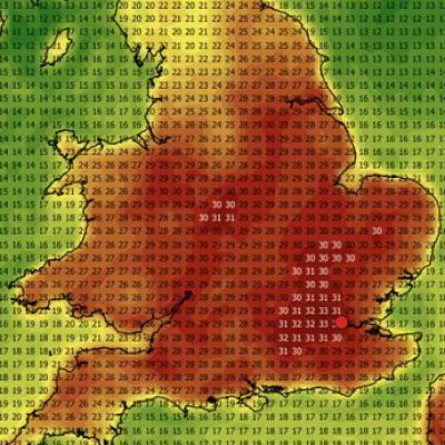
Meanwhile, western Europe is experiencing a heat dome, where warm air is trapped under a persistent high-pressure system. The first major heat event of 2026 has arrived unusually early, with temperatures in May rarely exceeding 30°C in northern regions like the UK, France, and Germany. Large parts of these countries are now seeing temperatures 10-15°C above the climate average.
Peak of the Heatwave
Monday and Tuesday are expected to be the peak of the heatwave in some areas, with temperatures widely above average before the worst heat becomes more confined to France and Iberia later in the week. France has already broken its May record of 30.5°C, with temperatures reaching the low 30s each day since Thursday, and higher values are expected. Temperatures more than 10°C above average are forecast in some places until the weekend, with parts of southwestern France potentially reaching 37-38°C.
Spain and Portugal
Spain and Portugal have not threatened their May records of 44.4°C and 40.0°C respectively, and are unlikely to do so, but they will experience the most prolonged hot spell. From the end of May into early June, temperatures across Iberia will remain 5-10°C above average. Temperatures have peaked in the high 30s each day since Thursday and are forecast to continue.