
Tropical Cyclone Fina is charting a torrential course towards the northern coast of Australia, posing a significant threat and potentially equalling a half-century-old weather record.
A Potentially Record-Breaking Storm
If Tropical Cyclone Fina makes landfall on the Northern Territory coast this Friday, it will match the record for the earliest cyclone to hit Australia since 1973. The current record is held by Cyclone Ines, which crossed the Kimberley coast on 21 November 1973. The earliest to cross the NT coast was Alessia on 27 November 2013.
Jonathan How, a senior meteorologist at the Bureau of Meteorology, confirmed the potential milestone. "Based on Fina’s track map it could also cross the coast on the 21st or 22nd of November, so that could equal the record for earliest landfall," he stated. This would also make it the earliest cyclone ever recorded for the Northern Territory.

Intensification and Forecasted Path
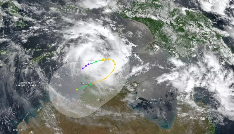
As of Wednesday, Fina was a category one system located approximately 370 kilometres north-east of Darwin. The Bureau's latest update, issued at 10.30am local time, indicated the cyclone was moving east and is expected to intensify into a category two cyclone before turning south on Thursday.
The bureau anticipates a potential impact on the Northern Territory coast on Friday or Saturday. The latest track maps suggest that Darwin, the territory's capital, could be affected by the severe weather system.
Climate Change and Cyclone Intensity
Experts are drawing links between the behaviour of such storms and the broader global climate crisis. Professor Steve Turton, an adjunct professor at Central Queensland University, explained that while a warming climate may lead to fewer tropical cyclones overall, their intensity is increasing.
"We do know that with climate change that we’re expecting the intensity of these storms to increase. We’re expecting them to intensify more rapidly. We’re already seeing those patterns," Professor Turton said. He noted that sea surface temperatures in the Timor Sea are currently above average and well above the 26.5C threshold required for cyclone formation.
He also highlighted a particular characteristic of Fina: its small size. "Because it’s small, it’s likely to spin up quicker. But it can also weaken quicker because of inertia. So these small cyclones can sometimes catch you unawares and suddenly they intensify very rapidly," he warned.
The most recent significant cyclone to impact Darwin was Cyclone Marcus in 2018, which made landfall as a category two system, bringing down trees and causing widespread power outages with wind gusts of up to 130km/h.


