A cold snap is sweeping across the UK this week, with forecasters warning of outbreaks of hail and thunder amid heavy showers. Temperatures are several degrees below the mid-May average across the Midlands and northern areas on Wednesday, as the country wakes up to an unsettled and blustery morning.
What is causing the cold weather?
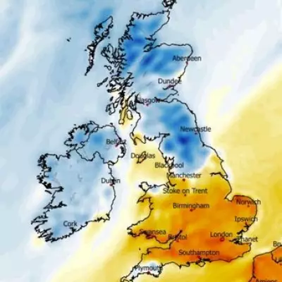
Northerly winds are dragging in cold air from northern Scandinavia and the Arctic circle. Average temperatures for this time of year typically range from 12 to 17C across the country, but the mercury is expected to hover around 14C in the south west and just 9C in parts of Scotland at the warmest on Wednesday.
It has been an unsettled start to the day with blustery showers in the north and south east. The Met Office has warned that wet conditions could turn thundery, with a risk of heavy rain and hail in the east later in the afternoon.

Regional forecasts
However, sunshine is forecast in some areas, particularly in the west of England. Wet and windy weather is expected to continue into Thursday, with heavy showers forecast across the east and west of England and Scotland. The Met Office said low pressure will become dominant, with showers expected to turn thundery in these areas and temperatures remaining cool.
The outlook for Friday and into the weekend is drier, as showers are expected to clear, making way for some cloud and spots of sunshine. But temperatures are expected to remain cool until Sunday.
Looking ahead
Warmer weather is on the horizon. Met Office forecasters predict sunny conditions with temperatures matching seasonal norms by the end of next week, which could see the mercury hit above 20C in time for the bank holiday weekend.
Detailed forecast
Wednesday: A blustery and cool day with a mixture of sunshine and showers. The showers will be heavy in places with a risk of hail and thunder, especially in the east. Showers may also merge into bands to give some longer spells of rain.
Tonight: A cool and breezy evening with further showers. Overnight, some inland areas will become dry with lengthy clear spells developing.
Thursday: Another day of sunshine and showers, with the showers heavy and thundery in places. A more prolonged spell of rain is possible for a time in the west. Feeling cool.
Outlook for Friday to Sunday: Drier on Friday and Saturday with just a few showers, but remaining on the cool side. A band of rain is then likely to move in from the west on Sunday.