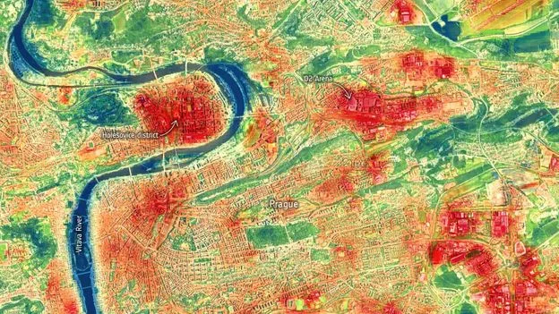
Satellite images captured from the International Space Station are offering a stark visualisation of urban heat stress, showing how parks, rivers and white-painted roads can significantly lower temperatures in densely populated areas. The images, taken during the June 2022 heatwave in Prague, reveal the Vltava River and city parks as ribbons of cool blue and green against a backdrop of hot red and orange, where land surface temperatures reached 45°C.
The data, collected by NASA’s ECOSTRESS instrument, is being used by city planners to identify hotspots and implement cooling measures. In Los Angeles, atmospheric scientist Glynn Hulley worked with the city council to pinpoint the hottest streets, which were then coated with a special reflective pavement. Subsequent satellite images showed the coating had cooled the roads by 1–2°C, helping secure $6 million in state funding for further projects.
Heat-related deaths are rising globally—more than 20,000 in Europe in 2022, with the UK recording its first 40°C day. In Texas, at least 13 deaths have been linked to the current heatwave, as forecasters warn temperatures could exceed 43°C. The ECOSTRESS maps, which update every few days for cities including London, Paris and Melbourne, highlight that areas within a 10-minute walk of a park can be 3°C cooler than those further away.
A 2022 study in Beijing using similar data found that parks with water features cool both the park and surrounding areas more effectively than green spaces alone. Researchers hope these satellite images will become a standard tool for urban climate resilience, helping cities combat the deadly effects of extreme heat.