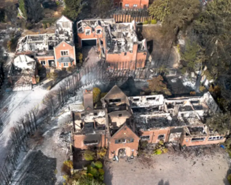
An extraordinary summer of wildfires has left its mark across Britain, from scorched heathlands in the New Forest to smouldering valleys in south Wales and burned-out homes in Stourbridge. To most, these charred landscapes look like devastation, but to a trained wildfire investigator, they are full of clues.
Heat-scorched leaves can become frozen in position, preserving evidence of wind direction as the fire passed through. Soot or staining on rocks, the pattern of fallen grass and bracken, and how stems have burned, provide further information about how the fire moved. By combining such clues, investigators can work backwards through a fire, narrowing their search to a likely area of origin.
Investigation gaps
Yet few people are trained to read a burnt landscape in this way. While fire crews routinely record a probable cause, a 2023 Forestry Commission report warned that these judgments were generally made by personnel with limited or no specialist training, leaving their accuracy “open to scrutiny”. More serious or complex fires may be referred to specialist fire investigators, but their expertise is generally in structural fires, rather than burning vegetation.
“Wildfire investigation is a different discipline, almost a completely different world,” said Rob Gazzard, the Forestry Commission’s wildfire contingency planning adviser, who co-authored the report. Andy Elliott, the UK’s only serving fire officer trained in specialist wildfire origin, said: “At the moment there is no capability for wildfire fire investigation in the UK, full stop.” He spoke in his capacity as founder of the wildfire training and consultancy business WildfireTaC.
Without specialist investigation, the Forestry Commission warned, preconceived ideas about what starts wildfires can influence conclusions, potentially misdirecting prevention efforts. For example, despite UK campaigns often focusing on discarded cigarettes, “research undertaken by wildfire scientists has determined that the cigarette as a cause is extremely unlikely and has been debunked by most eminent wildfire investigators”, the report said. Similar uncertainty surrounds disposable barbecues, which various organisations have called to be banned.
Prevention and prediction
The Forestry Commission is seeking to address this, with plans for two courses teaching people how to preserve evidence at wildfire scenes, and how to investigate wildfire origins and causes. Both are awaiting funding. For Gazzard, understanding the cause of wildfires is fundamental to prevention. England alone experiences roughly 30,000 vegetation fire ignitions each year, and “preparedness and prevention is where you win the wildfire”, he said. “It’s not about response.”
This year’s summer was the UK’s hottest on record, coupled with extreme and persistent drought. “The UK basically has been a tinderbox,” said Prof Stefan Doerr, a wildfire researcher at Swansea University. Although last year set a record for land burned by wildfires, by mid-August this year firefighters in England and Wales had already attended more wildfires than in the whole of 2025. “Fires are starting to become much more difficult to control. They’re also starting to destroy people’s homes, businesses and vehicles,” Elliott said.
Hotter, drier conditions could also mean that previously minor ignition sources start more fires, such as lightning or birds striking overhead power cables. “The bird will typically receive a very considerable voltage, catch fire and drop to the ground,” said Elliott. “Now we’re seeing conditions where the vegetation is very dry, bird strikes could be contributing to more fires.”
Changing fire seasons
The timing of Britain’s wildfires is changing too. Traditionally, they predominantly occurred in late winter and spring, when dead vegetation provides plentiful fuel. By summer, most of the landscape has greened up, creating a natural barrier to fire. Prolonged drought can disrupt this, creating parched, brown summer landscapes. A recent study in the journal Environmental Research Letters found that the UK’s wildfire season lengthened from between one and four months in 2011-16 to between six and nine months in 2017-21.
“Summer fires are much more difficult to put out, and they’re also much more dangerous in many ways,” Doerr said. Summer droughts can dry out grasses and crops extending right up to towns and homes, making fires too intense to tackle directly. “They’ll cross roads quite happily, and they move into people’s gardens and into their homes,” said Elliott. The environmental consequences can also be more severe, with fires capable of burning down into underlying peat layers, hindering regeneration and releasing additional carbon.
To predict how and where fires will spread, researchers have been burning samples of British wildfire fuels in a laboratory cone calorimeter, measuring how readily they ignite and how much heat they release at different times of year. These experiments contributed to the development of a UK wildfire-behaviour prediction system known as FireInSite, which firefighters use to predict how rapidly a fire may spread and how large its flames could become. “If, for example, it tells you you’re going to get flame lengths of six to eight metres, then attacking it with a fire beater is just not going to work, because you’re looking at helicopters,” said Elliott. “It also tells you when to step back and let the fire burn.”
However, FireInSite’s predictive power is limited. “Our model tells you how a fire will burn. It won’t tell you where the fire will go,” said Doerr. This requires a different kind of modelling, combining information about how individual fuels burn, with terrain, weather and the precise patchwork of vegetation. Fire spread models exist in other countries, but they are built around local fuel types. “There’s a certain element of randomness with fire that no model will ever be able to recreate,” said Prof Tom Smith, of the London School of Economics, who is trying to adapt fire-spread models to UK landscapes.
Researchers could simulate thousands of fires starting at different points and calculate the probability of a fire reaching particular places, identifying high-risk communities or “pinch points”. This could help develop evacuation plans, potentially avoiding tragedies such as the 2017 Pedrógão Grande fire in Portugal. “The beauty of modelling is you can run hundreds of [simulations], and you don’t destroy any landscape. You don’t kill anybody,” Elliott said. “You just keep running the models, and you learn from them.”
A big obstacle is that Britain lacks a sufficiently detailed map of its wildfire fuels. FireInSite relies on users selecting the vegetation they see, but a spread model needs to know what vegetation a fire will encounter as it travels. “In the UK, a lot can happen in 30 metres,” Smith said. For now, researchers can construct detailed fuel maps for relatively small areas using aerial imagery, but doing this for the whole country is another matter.
Severe wildfires were once unusual features of Britain’s green summers. Increasingly, they look like something we will have to learn to live with. Understanding how they start and where they are likely to go may be our best shot at stopping more of them from becoming disasters.