The Met Office has broken its silence on when the persistent rain across the UK will finally subside, with forecasts pointing to a significant shift towards warmer, sunnier weather. After a series of downpours at the start of June, following a record-breakingly hot end to May, the national weather service has released a long-range forecast indicating that high pressure will soon dominate, bringing a welcome respite.
High Pressure to Bring Settled Conditions
According to the Met Office, the transition to a more settled weather pattern is expected to begin around mid-June. A statement covering the period up to June 22 explains: "The start of this period will see a transition to a generally more settled weather pattern for much of the UK, as high pressure exerts more influence." This will be most noticeable across southern and eastern parts, while northwestern areas may remain cloudier with some rain at times.
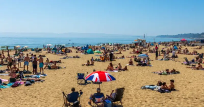
As the high pressure builds, temperatures are set to rise. The Met Office notes a "potential for very warm or hot conditions to become established by mid-month, especially across parts of England and Wales." This aligns with weather maps from WXCharts, which predict temperatures could hit 30C in London on June 22.

Potential for 30C Temperatures
New weather maps suggest that June 22 could see the mercury soar to 30C in the capital, with other parts of southern England also experiencing heatwave conditions. The Met Office's long-range forecast supports this, stating that "high pressure is favoured to remain close by to the UK towards the end of this period, bringing widely settled conditions and often above average temperatures."
From June 23 onwards, the forecaster indicates that high pressure is likely to remain nearby, bringing "a lot of dry weather." However, the exact position of the high pressure is uncertain, which could influence temperatures. The Met Office adds: "Whilst settled conditions look most likely, with a lot of dry weather in the offing, temperatures are more uncertain, though the potential does exist for further hot spells, especially in the south."
Outlook into July
Looking further ahead into July, the Met Office suggests that pressure may lower from the south, increasing the chance of thunderstorms. This could bring a change from the settled pattern, but for now, the focus is on the imminent warm spell.
Five-Day Forecast
In the immediate term, the Met Office five-day forecast indicates a mixture of sunny spells and showers for most areas, with showers most frequent in the north and west. Temperatures will feel rather cool, below normal for the time of year. However, by the weekend, high pressure is expected to develop, bringing sunny spells and rising temperatures.
Specifically, Thursday is expected to bring a spell of wet and windy weather, followed by a cloudy Friday with patchy rain. But from Saturday, high pressure will take hold, leading to sunnier conditions and a gradual warm-up.
Summary
In summary, the UK is set to experience a significant weather shift from persistent rain to warm, settled conditions, with the potential for temperatures to reach 30C by June 22. The Met Office advises that while the exact details remain uncertain, the trend is towards drier and warmer weather, especially in southern and eastern areas.