The Met Office is forecasting 'very warm or hot conditions' for Wales as temperatures are set to climb this weekend. After a week of drizzle and heavy rain in some areas, the weather is expected to heat up, with temperatures likely reaching the high 20s Celsius.
Warmer and Drier Conditions Ahead
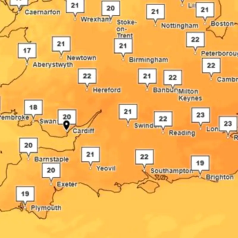
More settled conditions are predicted with less rain and more sunshine across the UK, according to the Met Office. In Monmouth, temperatures are forecast to be 25C on Saturday, 27C on Sunday, and 26C on Monday. A UK heatwave threshold is met when a location records at least three consecutive days with daily maximum temperatures meeting or exceeding the heatwave temperature threshold.
Rain Before the Warmth
Unfortunately for some, the lead-up to the warmer weather will consist of rain as a 'showery regime will dominate for most of this week,' the forecaster says, along with a chance of hail and thunder. However, the outlook improves for the weekend.

The Met Office forecast states: 'A return to more settled conditions from the weekend with the likelihood of temperatures reaching the high 20s is the latest forecast from the Met Office.' In the lead-up to this spell of fine weather, conditions will remain unsettled. A showery regime will dominate for most of this week, including some brighter interludes but also plenty of showers, some of which will be heavy with a chance of hail and thunder in places.
Temperatures Could Reach Almost 30C
Across the UK, temperatures could climb to almost 30C again, a welcome return for many after the late May bank holiday heatwave. Deputy Chief Meteorologist Steven Keates said: 'From this weekend the UK forecast will have a distinctly warmer and drier component with a prolonged spell of above-average temperatures, with values in some locations quite likely to reach 27 to 29C, with the potential for higher values than this.'
Met Office forecasters expect the warm spell to last well into the following week at least. The long-range forecast for the UK predicts that there is potential for very warm or hot conditions to become established by mid-month, especially across parts of England and Wales.
Outlook for Mid-June
The forecast for Saturday, June 13, to Monday, June 22, says: 'The start of this period will see a transition to a generally more settled weather pattern for much of the UK, as high pressure exerts more influence. This will be most noticeable across southern and eastern parts, whereas areas further northwest could often be cloudier with some rain at times. With the build of pressure will come an increase in temperatures, with the potential for very warm or hot conditions to become established by mid-month, especially across parts of England and Wales.'
High pressure is favoured to remain close by to the UK towards the end of this period, bringing widely settled conditions and often above-average temperatures.