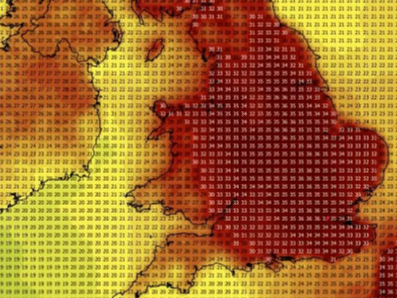
Liverpool and Merseyside are at the centre of a blistering summer lockdown as weather maps confirm the third major mega-heatwave of 2026 is tightening its grip. New long-range radar charts show deep crimson plumes of hot air completely swallowing the North West, sending temperatures rocketing across the region. While an easterly breeze has brought a slight dip in mercury for some eastern coastal areas, the core of this relentless furnace is now sitting directly over the streets of Liverpool.
When Will the Next Heatwave Hit?
Forecasters warn the intense hot spell is far from over, with temperatures set to consistently smash into the low 30s and peak at a sweltering 34°C. Shock weather models reveal the region is trapped in this oven for at least another 15 days, meaning the extreme heat will fry Merseyside until the end of July, reports The Mirror. The brutal high-pressure system has forced health bosses to issue urgent alerts across Liverpool as UV levels pierce through the atmosphere. Built-up urban areas face a total sleep wipeout, with night-time temperatures refusing to budge and triggering sticky "tropical nights" above 20°C.
Wildfire and Thunderstorm Risks
Emergency crews have issued an immediate wildfire watch across nearby parched grasslands, pleading with the public to prevent accidental blazes on the bone-dry landscape. Experts say the oppressive air mass won't budge until late in the month, when a volatile Atlantic frontal system threatens to trigger violent, explosive thunderstorms.
Week Ahead Forecast
Looking at the week ahead, Met Office meteorologist Alex Burkall said on the Met Office YouTube channel: "Temperatures will start to drop a little, so it won’t be quite as hot. For many places, highs will ease into the high 20s, with 30°C less likely on Friday than earlier in the week." He added: "Temperatures are set to drop a little further on Saturday, though it should stay dry."