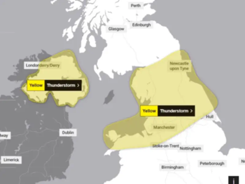
A yellow thunderstorm warning has been issued by the Met Office for 40 UK areas, including Greater Manchester, with the alert set to come into effect at 7pm on Wednesday, August 19.
The Met Office has issued two separate thunderstorm warnings affecting parts of the UK today. One covers Northern Ireland, while the other affects parts of northern England.
Northern Ireland Warning
Northern Ireland is expected to be hit first by the thunderstorms, with the warning coming into effect at 12pm. It is set to affect six counties in Northern Ireland until 11:59pm.

"Heavy showers and thunderstorms likely to lead to travel disruption and flash flooding in some places," the Met Office warning reads.
Second Warning for Northern England
At 7pm, a second warning comes into effect across parts of north west England, north east England, East Midlands, Wales, and Yorkshire. This warning will remain in place until 10am on Thursday, August 20.
The Met Office has warned that the following impacts could be seen in the affected areas:
- Driving conditions could be affected by spray, standing water and/or hail, leading to longer journey times by car and bus
- Some flooding of a few homes and businesses likely, leading to some damage to buildings or structures
- Probably some damage to a few buildings and structures from lightning strikes
- Delays to train services are possible
- Some short-term loss of power and other services is likely
Further detail from the Met Office reads: "Heavy showers will develop this evening, becoming more frequent and widespread overnight. These are likely to bring 15 to 20 mm in an hour in some areas with as much as 30 to 50 mm falling in a period of six hours in some places."
"These accumulations may lead to a few places seeing some flooding. Alongside the rain, some showers are likely to be thundery, bringing the additional hazards of lightning and hail. The showers will ease from the northwest Thursday morning."
Full List of Affected Areas
The Met Office activates its severe weather alert system when there is likely to be impacts from the weather. There are varying severities from yellow, amber and red.
Here are all of the UK areas affected by the Met Office warning, from 7pm on Wednesday until 10am on Thursday:
East Midlands: Derbyshire
North East England: Darlington, Durham, Gateshead, Hartlepool, Middlesbrough, Newcastle upon Tyne, North Tyneside, Northumberland, Redcar and Cleveland, South Tyneside, Stockton-on-Tees, Sunderland
North West England: Blackburn with Darwen, Blackpool, Cheshire East, Cheshire West and Chester, Cumbria, Greater Manchester, Halton, Lancashire, Merseyside, Warrington
Wales: Conwy, Denbighshire, Flintshire, Gwynedd, Isle of Anglesey, Wrexham
Yorkshire and Humber: East Riding of Yorkshire, North Yorkshire, South Yorkshire, West Yorkshire, York
Warning from 12pm until 11:59pm on Wednesday for Northern Ireland: County Antrim, County Armagh, County Down, County Fermanagh, County Londonderry, County Tyrone.