Faced with ageing infrastructure and a pressing need for repairs, cities and states across the United States are increasingly turning to artificial intelligence to monitor road conditions and prioritise critical fixes.
This technological shift is transforming how authorities identify hazards, from crumbling guardrails to pervasive potholes, allowing for faster and more efficient maintenance responses.
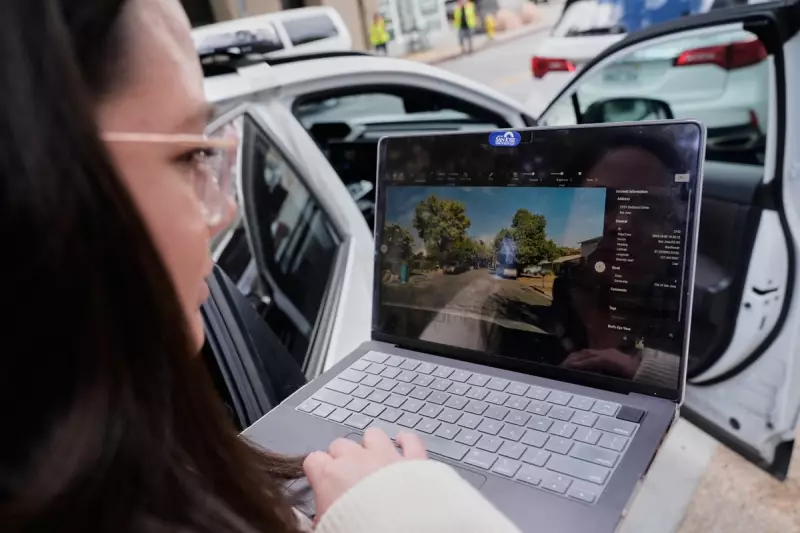
From Hawaii's Highways to San Jose's Streets
In a bold move to reverse a recent spike in traffic fatalities, officials in Hawaii have launched the 'Eyes on the Road' campaign. The initiative involves distributing 1,000 free dashboard cameras, valued at $499 each, to motorists. These dashcams use AI to automatically inspect guardrails, road signs, and pavement markings, instantly distinguishing between minor wear and emergencies that require immediate crew dispatch.

Richard Browning, chief commercial officer at Nextbase, the company behind the technology, emphasised the efficiency gain, stating this is not a monthly review process but a dynamic, real-time solution.
The state's unique challenges, including shipping equipment to islands and dealing with topographical constraints, make this AI-driven approach particularly valuable. The programme's urgency is underscored by a grim statistic: Hawaii recorded its 106th traffic fatality of 2025 in October, surpassing the total for all of 2024.
Meanwhile, in San Jose, California, the city has reported remarkable success by mounting cameras on municipal vehicles like street sweepers. The system correctly identified potholes 97% of the time, leading to an expansion of the effort to parking enforcement vehicles.
Building a Smarter Safety Network
The ambition extends beyond individual cities. San Jose's Mayor, Matt Mahan, a former tech entrepreneur, advocates for a shared AI database where cities can contribute imagery. This would allow the system to recognise road problems it has encountered elsewhere, dramatically speeding up the identification process.
This collaborative vision led to the establishment of the GovAI Coalition in March 2024, which includes local governments from California, Minnesota, Oregon, Texas, Washington, and the state of Colorado.
Not all solutions require cameras. Companies like Cambridge Mobile Telematics use cellphone data from enrolled drivers with their StreetVision system to pinpoint dangerous road conditions. In one instance, the software detected a pattern of aggressive braking on a Washington, D.C. road, traced back to a bush obscuring a stop sign—a problem solved with a pair of garden shears.
In Texas, which boasts more roadway lane miles than the next two states combined, AI tools are being used to scan vast distances. They recently analysed 250,000 lane miles (402,000 kilometres) to find old street signs long overdue for replacement, a task described as a 'force multiplier' for overwhelmed transport departments.
The Road Ahead: Paving the Way for Autonomy
Experts view these current applications as foundational steps towards a future dominated by autonomous vehicles. Mark Pittman, CEO of Blyncsy, predicts that within eight years, almost every new vehicle will come equipped with a camera.
This evolution means transportation agencies must now consider how infrastructure appears to both human drivers and automated systems, bridging a crucial divide for the future of transport.
As America's roads get a digital upgrade, AI is proving to be an indispensable co-pilot in the journey towards enhanced safety and smarter infrastructure management.