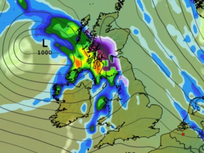
Weather forecasting models show up to two inches of snow could settle in some parts of the UK during a blast of wintry weather later this month. The GFS model shows a weather front moving across the country from the east in the early hours of October 22, with the precipitation falling as snow over Scotland and some parts of northern England.
Snow expected across Scotland and northern England
The maps show that at 6am, the heaviest flurries are expected in western Scotland. The snow is tracked to move eastwards throughout the morning. Maps for 9am show powerful flurries stretching from the far north of Scotland all the way down to North Yorkshire. Where they are most intense over high ground, the data suggests snow could be falling at a rate of around 4mm per hour.
The GFS model suggests the snow will have largely died down by midday, with some light flurries persisting in northern and central Scotland. Snow depth predictions show as much as 5cm (two inches) could settle over high ground in central and northern Scotland, with 1cm on the cards over peaks in northern England.
Counties likely to see flakes
The maps suggest 28 counties could see some flakes during this wintry blast. They are all in Scotland or northern England.
In Scotland, the counties are: Ross-shire and Cromartyshire, Inverness-shire, Aberdeenshire, Angus, Perthshire, Nairnshire, Morayshire, Banffshire, Argyllshire, Stirlingshire, Dunbarton, Clackmannanshire, Kinross-shire, Fife, West Lothian, Midlothian, East Lothian, Berwickshire, Roxburghshire, Lanarkshire, Peeblesshire, Selkirkshire, Dumfriesshire and Ayrshire. In England, the counties are: Cumbria, Yorkshire, Northumberland and Durham.
El Nino could bring more snow this winter
This comes as forecasters have warned El Nino could bring some extreme weather to the UK this winter. This year’s El Nino is expected to be the strongest in living memory. While it tends to cause extremely warm temperatures in the summer, it can lead to storms in the winter.
The Met Office has said the weather phenomenon may cause the polar vortex to collapse, which can lead to sudden stratospheric warming. This process leads to changes in the jet stream, possibly forming a ‘blocking pattern’ which keeps cold air and snow locked in place above the UK.
"Through the latter part of the winter, following a peak in El Niño, the stratospheric Polar Vortex can become weaker, leading to an increased chance of Sudden Stratospheric Warming (SSW) events unfurling, increasing the potential for cold weather," the Met Office said.