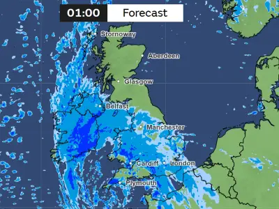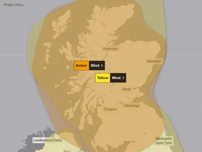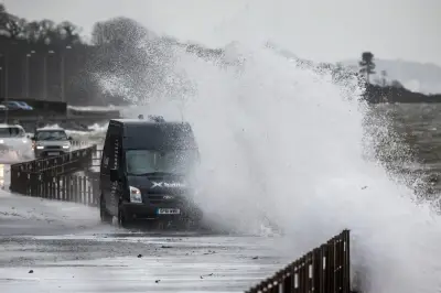
Households in 72 areas of the UK are being urged to keep their doors and windows locked until 9pm on Sunday, October 25, as Storm Boelo sweeps the country. Amber and yellow weather warnings for wind are currently in force for large swathes of the UK until 9pm this evening, with gusts of up to 80mph forecast within the affected areas.
Warnings in Force
The Met Office said winds of 60 to 70mph will be widespread within the warning area, while some exposed coastal locations could be hit by more powerful gusts of 80mph. The amber warning covers Scotland and parts of northern England, and sits within a wider yellow weather warning extending further south into England and north Wales.
Storm Boelo follows Storm Austen, the first named storm of the season, which brought gusts of up to 76mph to parts of the UK on Friday, and the disruptive weather continues into the weekend.
Potential Disruption
Homes in the affected areas are being warned to brace for disruption as strong winds may lead to power cuts and transport disruption, while the gusts could also cause damage to buildings and property, such as tiles blown from roofs, and potential danger to life from flying debris.
Met Office Chief Forecaster Jason Kelly said: “Storm Boelo will be felt across the UK this weekend, with the strongest winds and greatest potential for disruption in the north. Amber warnings are in place across mainland Scotland, parts of Northern Ireland and the far north of England, where gusts of 60-70mph are expected widely, with the potential for 80mph in exposed coastal locations.
“Strong winds will also affect other parts of the UK, with gusts of 50-60mph possible in places. Heavy rain will provide an additional hazard, particularly in the north, bringing the potential for further impacts.
“People should prepare for the potential for disruption, particularly to travel and power supplies. Secure loose items outside, plan ahead if you are travelling and keep up to date with the latest forecast and warnings for your area.”
Protecting Your Property
Met Office advice urges households to protect their property by securely locking all windows and doors, as well as removing any loose items from outside homes, such as outdoor lights, lanterns, hanging baskets, garden furniture and bins, as these could easily smash or blow over in the blustery conditions. Households are also advised to gather torches, batteries, mobile phone power packs and other essential items in case of power cuts.
In its advice on staying safe during storms, the Met Office said: “Secure loose objects such as ladders, garden furniture or anything else that could be blown into windows and other glazing and break them. Close and securely fasten doors and windows, particularly those on the windward side of the house, and especially large doors such as those on garages.
“Park vehicles in a garage, if available; otherwise keep them clear of buildings, trees, walls and fences. Close and secure loft trapdoors with bolts, particularly if roof pitch is less than 30°.
“If the house is fitted with storm shutters over the windows then ensure that these are closed and fastened. If chimney stacks are tall and in poor condition, move beds away from areas directly below them.”
Steven Walley, landscaper and gardening expert from London Stone, warns it is important to take steps to protect your home during stormy weather to prevent as much damage as possible. He said: “Nature is extremely powerful and heavy wind and rain can cause severe damage to your garden through flying debris or flooding.
“To prevent as much harm as possible, it’s important to ensure we’re taking precautions to protect our homes in harsh weather conditions. Make sure all doors and windows are locked shut.
“If you know a storm or weather warning is set to take place in your region, start taking precaution. First, make sure that there are no obvious entry points by making sure all windows and doors are locked shut. This will help to prevent damage from heavy rain seeping in and will help to reduce pressure on windows from strong winds.”
Affected Areas
Listed are the 72 areas of the UK covered by weather warning for wind until 9pm on Sunday, October 25:
- Central, Tayside & Fife: Angus, Clackmannanshire, Dundee, Falkirk, Fife, Perth and Kinross, Stirling
- Grampian: Aberdeen, Aberdeenshire, Moray
- Highlands & Eilean Siar: Na h-Eileanan Siar, Highland
- Orkney & Shetland: Orkney Islands
- Strathclyde: Argyll and Bute, East Ayrshire, East Dunbartonshire, East Renfrewshire, Glasgow, Inverclyde, North Ayrshire, North Lanarkshire, Renfrewshire, South Ayrshire, South Lanarkshire, West Dunbartonshire
- SW Scotland, Lothian Borders: Dumfries and Galloway, East Lothian, Edinburgh, Midlothian Council, Scottish Borders, West Lothian
- North East England: Darlington, Durham, Gateshead, Hartlepool, Middlesbrough, Newcastle upon Tyne, North Tyneside, Northumberland, Redcar and Cleveland, South Tyneside, Stockton-on-Tees, Sunderland
- North West England: Blackburn with Darwen, Blackpool, Cheshire East, Cheshire West and Chester, Cumbria, Greater Manchester, Halton, Lancashire, Merseyside, Warrington
- Yorkshire & Humber: East Riding of Yorkshire, Kingston upon Hull, North East Lincolnshire, North Lincolnshire, North Yorkshire, South Yorkshire, West Yorkshire, York
- East Midlands: Derbyshire, Lincolnshire, Nottinghamshire
- West Midlands: Staffordshire, Stoke-on-Trent
- Wales: Conwy, Denbighshire, Flintshire, Gwynedd, Isle of Anglesey, Wrexham
The warnings remain in force until 9pm, with households advised to follow the Met Office guidance to secure properties and prepare for potential power cuts and travel disruption.