The Met Office has named 78 areas where households should prepare for potential power cuts as Storm Boelo brings heavy rain and gusts of up to 80mph across the UK.
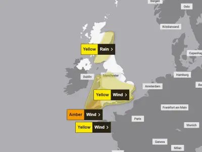
Yellow and amber weather warnings have been issued for Saturday, Sunday and Tuesday. The weather agency warned that the intense conditions could cause disruptions, including power cuts.
Power cut preparations urged
The Met Office stated: "There is a good chance that power cuts may occur, with the potential to affect other services, such as mobile phone coverage." UK households have been urged to prepare by stocking up on essential items.
"People cope better with power cuts when they have prepared for them in advance. It's easy to do; consider gathering torches and batteries, a mobile phone power pack and other essential items," the Met Office explained.
Safety warnings during the storm
Brits have also been warned that there could be danger to life, and it has been urged that people stay indoors as much as possible throughout the storm. If going outside is necessary, the Met Office advised avoiding walking or sheltering close to buildings and trees. Drivers should proceed carefully and slowly to minimise the impact of wind gusts.
Drivers should be aware of high-sided vehicles or caravans on more exposed roads and be cautious when overtaking, giving cyclists, motorcyclists, lorries, and buses more room than usual, the Met Office explained.
Storm Boelo's expected impact
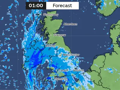
The Met Office outlined what Brits should expect on Sunday: "Very strong westerly winds associated with Storm Boelo are expected to bring fairly widespread gusts of 60 to 70 mph and gusts to 80 mph in exposed coastal areas. The strongest winds will initially affect western Scotland on Saturday evening, spreading eastwards overnight and through Sunday.
"High winds will be accompanied by periods of heavy rain and frequent showers. Whilst high winds are expected across a wider area with a yellow warning in force, there is a higher confidence in impacts and disruption taking place within this amber warning area. The winds will gradually ease from the southwest through Sunday."
The full list of 78 areas at risk includes Aberdeen, Aberdeenshire, Angus, Argyll and Bute, Blackburn with Darwen, Blackpool, Cheshire East, Cheshire West and Chester, Clackmannanshire, Conwy, County Antrim, County Armagh, County Down, County Fermanagh, County Londonderry, County Tyrone, Cumbria, Darlington, Denbighshire, Derbyshire, Dumfries and Galloway, Dundee, Durham, East Ayrshire, East Dunbartonshire, East Lothian, East Renfrewshire, East Riding of Yorkshire, Edinburgh, Falkirk, Fife, Flintshire, Gateshead, Glasgow, Greater Manchester, Gwynedd, Halton, Hartlepool, Highland, Inverclyde, Isle of Anglesey, Kingston upon Hull, Lancashire, Lincolnshire, Merseyside, Middlesbrough, Midlothian Council, Moray, Na h-Eileanan Siar, Newcastle upon Tyne, North Ayrshire, North East Lincolnshire, North Lanarkshire, North Lincolnshire, North Tyneside, North Yorkshire, Northumberland, Nottinghamshire, Orkney Islands, Perth and Kinross, Redcar and Cleveland, Renfrewshire, Scottish Borders, South Ayrshire, South Lanarkshire, South Tyneside, South Yorkshire, Staffordshire, Stirling, Stoke-on-Trent, Stockton-on-Tees, Sunderland, Warrington, West Dunbartonshire, West Lothian, West Yorkshire, Wrexham, and York.