Three Areas Set for Rain as Heatwave Peaks
The Met Office has identified three parts of the UK set for rain this Friday, as much of Britain swelters under a rare red weather warning for extreme heat. Temperatures are poised to hit 40°C on Wednesday and Thursday (June 24-25) in parts of England and Wales as a heat dome settles over western Europe.
Red Warning in Force
A red Met Office weather warning for extreme heat covering an area from London to Swansea and Somerset to Birmingham came into force at 9am on Wednesday and lasts until 9pm on Thursday. The forecaster said some heavy thundery showers will move north from the South West of England from Thursday night into the early hours of Friday morning.
Northern Areas Affected
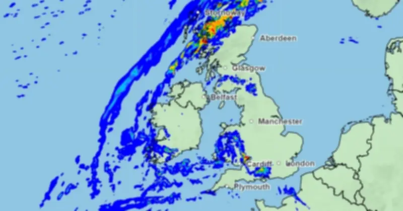
Oliver Claydon from the Met Office said: "Further north there will be rain across Scotland, especially northern Scotland, and parts of Northern Ireland. So for many parts of central and southern England it will remain dry until the weekend." Weather maps show rain moving north across Wales, the Midlands and the North of England on Friday morning.

Weekend Change
Mr Claydon added that some heavy showers are possible in the South East on Saturday (June 27), but the biggest change comes on Sunday (June 28) as cooler air moves in and brings showers for many areas. Before then, the UK is set to see the June temperature record "absolutely smashed," according to BBC Weather forecaster Chris Fawkes.
Temperature Records
Chris Fawkes told the BBC: "I think this afternoon we’re probably looking at highs reaching around 37C, maybe 38C, so by a big margin we are likely to set a new June temperature record." The current record for June of 35.6°C was set in Hampshire during the heatwave of 1976. During the peak on Wednesday and Thursday, temperatures could come close to the UK’s all-time high of 40.3°C, measured in Lincolnshire in July 2022.
Overnight Warmth and Travel Disruption
Overnight, temperatures across many areas remained above 20°C. Brize Norton in Oxfordshire did not dip below 22.3°C and Heathrow, west London, stayed above 22.1°C. Network Rail warned of "significant disruption" across England and Wales, imposing speed restrictions to minimise the risk of buckled rails and sagging overhead wires. The AA reported breakdown callouts were "considerably more challenging than usual," with callouts on Tuesday about 6% higher than normal.