The Met Office has issued severe weather warnings as Storm Benjamin prepares to unleash its fury across the United Kingdom, with forecasters predicting potentially dangerous conditions through Wednesday.
Double Weather Threat: Wind and Rain Warnings
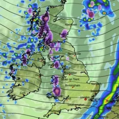
Meteorologists have raised amber alerts for both wind and rain, anticipating gusts reaching up to 75mph in exposed coastal areas and up to two inches of rainfall in some regions. The storm system, named by the Met Office, represents a significant weather event that could disrupt travel and cause localised flooding.
Timeline of the Tempest
The severe conditions are expected to develop throughout Wednesday, with the worst weather hitting during the afternoon and evening hours. The Met Office warning specifically covers the period from early morning until late evening, indicating a prolonged period of unsettled weather.
Regional Impact Assessment
While the entire UK will experience some effects from Storm Benjamin, certain areas face more severe threats. Southwestern coastal regions are particularly vulnerable to the strongest winds, while western facing hills could see the highest rainfall accumulations.
Travel Disruption Expected
Transport networks are preparing for significant disruption. Rail services may face delays and cancellations due to potential debris on tracks and safety concerns in high winds. Road users, particularly those driving high-sided vehicles, are advised to exercise extreme caution.
Public Safety Advice
The Met Office urges residents to secure loose outdoor items and avoid unnecessary travel during the peak of the storm. Emergency services are on standby to respond to weather-related incidents, including potential power outages and fallen trees.
This severe weather event comes as part of an unsettled pattern affecting the UK, with meteorologists continuing to monitor the situation closely and providing regular updates as Storm Benjamin develops.


