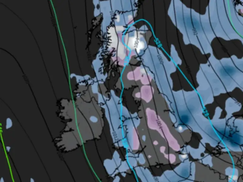
Weather modelling data suggests snow could fall across parts of England, Scotland and Wales next week, with some flurries potentially reaching southern England. The GFS weather model indicates snow may begin in northern Scotland on the afternoon of November 10 before moving southward.
Snowfall Timeline and Affected Areas
Data for 3am on November 11 shows intense flurries hitting North Wales and the north-west of England, with snow potentially falling at a rate of around 4mm per hour before drifting south-eastward. By 6am, the heaviest snow is expected in eastern parts of England, with some flurries possibly reaching areas near the south coast.
Snow coverage data for 9am shows swathes of south-eastern, central and northern England could see snow settle on the ground, although accumulations are not expected to rise much above 1cm anywhere except hills in Scotland.
Counties Affected
In total, the GFS model maps suggest 50 counties could see some snow next week, all in England, Wales and Scotland. In England, affected counties include Northumberland, Durham, Cumbria, Lancashire, Yorkshire, Cheshire, Derbyshire, Nottinghamshire, Leicestershire, Staffordshire, Northamptonshire, Bedfordshire, Buckinghamshire, Hertfordshire, Essex, Oxfordshire, Berkshire, Surrey, Sussex and Herefordshire.
In Scotland, snow could affect Sutherland, Ross-shire and Cromartyshire, Inverness-shire, Nairnshire, Banffshire, Morayshire, Aberdeenshire, Kincardineshire, Angus, Perthshire, Argyllshire, Stirlingshire, Dunbarton, Lanarkshire, Peeblesshire, Midlothian, East Lothian, Dumfriesshire, Selkirkshire, Berwickshire and Roxburghshire. Welsh counties include Denbighshire, Merioneth, Montgomeryshire, Radnorshire, Brecknockshire, Glamorgan, Monmouthshire, Carmarthenshire, Cardiganshire and Caernarfonshire.
Met Office and BBC Forecasts
The Met Office has said temperatures are expected to turn colder towards the end of this week. For the coming days, the Met Office forecasts "variable cloud with scattered light showers," with the most frequent showers in the south-east and temperatures "near normal." From Wednesday through Friday, "variable cloud" and "light showers" will continue, with most places staying dry but "cold starts" with mist and fog in northern areas, turning colder by Friday.
The BBC forecast for this week states: "Tomorrow will be another largely dry day with sunny spells and patchy cloud for most, but a few scattered showers in the east. Thicker cloud may linger for southern and eastern Scotland though."
"High pressure staying in charge through the end of the week. For northern areas, light winds are expected, with sunny breaks and areas of low cloud. Patchy fog around each morning in places too. Further south, a little breezier but it will still be largely dry with variable low cloud and sunny breaks. A few showers will continue to affect southern and eastern coastlines though."