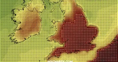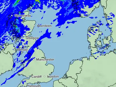
Storm Goretti, the first named storm of 2026, has been described by the Met Office as a 'multi-hazard event' expected to bring up to 30cm of snow to Wales and the Midlands, along with winds of up to 100mph in Cornwall and the Isles of Scilly. The storm, named by Météo France, has evolved into a 'weather bomb', with its central pressure dropping by 36 millibars in 24 hours, making it more powerful than Storm Ciarán in 2023 and the Great Storm of 1987.
A rare red warning for 'dangerous, stormy' winds has been issued for Cornwall and the Isles of Scilly, where winds of 99mph were recorded at St Mary's airport – a new record for the site. Amber warnings cover much of Wales and the Midlands, with heavy snow expected to cause travel disruption, power cuts, and potential risk to life and property. Birmingham Airport suspended its runway on Thursday night due to heavy snow.
More than 47,000 properties in the south-west, 5,000 in the West Midlands, and 2,000 in Wales were without power by Thursday evening, according to National Grid. Emergency alerts were sent to mobile phones in the Isles of Scilly and Cornwall. The Met Office warned that roofs could be blown off, power lines brought down, and large waves could throw debris onto coastal roads and seafronts.

Rail passengers have been advised to check journeys, with services cancelled across Wales, Cornwall, and north-west England. National Rail confirmed all trains in parts of south-west England would be cancelled on Thursday evening, and delays were likely on Eurostar routes. Major airports planned to operate normally, except Jersey and Guernsey, which closed at 6pm. Amber cold weather health alerts are in place until 11 January, with officials expecting a rise in deaths among the elderly and vulnerable.
The storm is expected to wane on Friday, but recovery efforts are already underway in Scotland after days of heavy snowfall. The National Grid advised keeping torches and fully charged phones ready, while water companies urged customers to protect exposed pipes rather than leaving taps running.