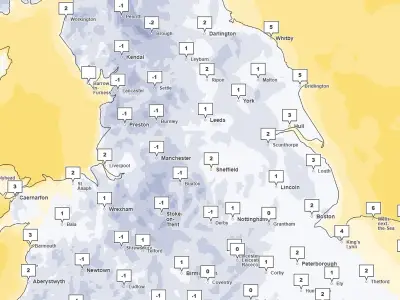
A 200-mile band of snow is forecast to sweep across the UK early next week as freezing Arctic air collides with incoming wet weather. The latest Met Office charts show snow sweeping horizontally across northern Wales and northern England from midnight on Monday, November 16, into the early hours of Tuesday, tracking northwards and eastwards through the night before breaking up.
The UK is already gripped by a bitter cold snap after temperatures plunged to -6.4C in Cumbria and Brecon on Thursday, November 12, with forecasters warning that further wintry disruption is on the way. Following another freezing Saturday, November 14, temperatures are expected to lift slightly on Sunday as Atlantic weather fronts push rainfall across the country, before icy Arctic air tightens its grip once again.
Snow to spread across 29 areas
By around 3am on Tuesday, snow is expected to take hold across southern Scotland, south of Glasgow, and sweep across northern England, reaching as far south as Nottinghamshire and Lincolnshire. Some regions could see accumulations exceeding 5cm, while hilly parts of central Scotland face up to 15cm.
The affected areas include Gwynedd, Conwy, Denbighshire, Flintshire, Wrexham, and Powys in Wales; Merseyside, Cheshire, Staffordshire, Derbyshire, Yorkshire, Nottinghamshire, Lincolnshire, Lancashire, Cumbria, Durham, Newcastle, and Northumberland in England; and Dumfries and Galloway, Scottish Borders, South Ayrshire, East Ayrshire, South Lanarkshire, North Lanarkshire, Perth and Kinross, Aberdeenshire, Moray, Highland, and Argyll and Bute in Scotland.
Forecasters warn of wintry showers
BBC weather forecaster Helen Willetts warned: "We can see that northerly wind coming back in later in the day pushing those weather fronts out of the way by the start of Monday and we are back into that sparkling Arctic air. So even at lower levels in the north we could see some snow showers and they will certainly be gathering in force across the northern part of Scotland."
"Tuesday looks quite an interesting day as we've got this next weather system running to the south of the UK, as it comes and bumps into the cold air we could have a spell of snow," she added. "It is a long way off at the moment but we will firm up, don't take this as read because it could be a little bit further north or south."
"But wherever that weather front grinds to a halt we could see a spell of snow primarily on the hills but not necessarily exclusively - we could see something at lower levels as well," she said. "We are staying in the colder air for much of next week."
Met Office outlook for the week
The Met Office's latest outlook for Monday through to Wednesday, updated at 4pm on Saturday, November 14, reads: "Sunny for most on Monday, but wintry showers over northeast Scotland and rain for the southwest later. From Tuesday, rain, hill snow in the north, showers, and strong coastal winds."
Northern Ireland's outlook for Monday to Wednesday, last updated at 4pm on Saturday, reads: "Showers and sunshine for Monday. Rain and hill snow for Tuesday. Largely dry with plentiful periods of weak winter sunshine on Wednesday. Temperatures seasonally low given the generally northerly winds."