Wales could see its first taste of winter snowfall next week, with the latest Met Office forecast maps showing wintry weather affecting areas across the country. Forecasters are predicting a sharp drop in temperatures this weekend, with patches of snow possible from Monday.
Cold snap brings freezing temperatures
A new cold snap is expected to bring below-freezing temperatures this weekend, with overnight lows hovering around -5C in many areas. The latest predictions suggest the colder conditions could also bring snow from Monday.
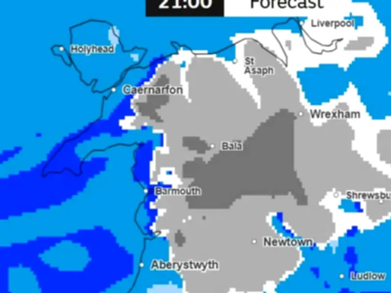
North Wales currently looks set to see the most significant snowfall, though patches of snow are also forecast further south, including areas north of Swansea and around Aberystwyth. The wintry weather is expected to move in on Monday evening, November 16, as a weather front blows in from the south-west.
Snowfall timeline and areas affected
According to the latest forecast maps, snow could begin falling at around 3pm, initially affecting areas north of Swansea and in Aberystwyth. By 3pm, areas such as Merthyr, Brecon, Builth Wells and Aberystwyth are forecast snowfall.
As the evening progresses, the snowy conditions are forecast to spread across parts of north Wales, to Gwynedd and rural parts of Denbighshire and Conwy by 6pm. Wrexham and Flintshire could also be experiencing snowfall by around 9pm.
Some areas could see particularly heavy snowfall, with the forecast suggesting more than 4mm of precipitation an hour in places. Further south and along the west coast, the maps also indicate the possibility of scattered wintry showers, with patches of snow expected in areas north of Swansea and around Aberystwyth.
Overnight snow and travel implications
By midnight, the heaviest snowfall is expected to move northwards, potentially sitting over parts of Conwy, Flintshire and Denbighshire. There could also be implications for travel along the A55. Snow is then forecast to continue into Tuesday morning, November 17, before conditions begin to clear between 6am and 9am.
The prospect of snow comes as the Met Office warns of a sharp overnight frost across much of England and Wales on Friday. In a post on social media, the forecaster urged people to get their winter bedding ready as temperatures plummet. It said: "Tonight may be the night to swap to the winter duvet (if you haven't already)! A sharp frost developing in the countryside across much of England and Wales but the frost perhaps less widespread across Scotland and Northern Ireland due to cloudier skies at times."
The colder conditions are expected to become more widespread as the new week gets underway, with temperatures potentially falling close to freezing in many parts of Wales.
Why snow is difficult to forecast
The Met Office has explained that predicting snowfall can be particularly challenging, with relatively small changes in temperature and wind direction potentially making the difference between rain, sleet and snow. It said: "Snow requires two key ingredients: cold air and moisture. A northerly airflow can bring colder Arctic air towards the UK, while easterly winds can draw cold continental air from Europe. If that cold air encounters moisture, either from a weather front or showers developing over the sea, precipitation has a greater chance of falling as snow."
The forecaster added that heavier precipitation can cool the air close to the surface, sometimes allowing snow to reach the ground, while lighter snowfall can melt before reaching the surface. Met Office meteorologists combine high-resolution computer models with radar observations and expert judgement to continually refine their forecasts.
It said the distinction between snow falling and snow settling was particularly important, as even relatively small amounts of snow or ice could affect transport networks, infrastructure and everyday journeys. The exact timing, location and amount of snowfall could still change as Monday approaches.
Confidence in where snow will fall and whether it will settle generally becomes higher closer to the event. Where snow has the potential to cause disruption, the Met Office can issue National Severe Weather Warnings to alert the public and organisations responsible for transport and road treatment. People across Wales are therefore being advised to keep an eye on the latest forecasts, particularly if planning journeys early next Tuesday.