UK Braces for 70mph Gale-Force Winds as Weather Maps Turn Purple
Grim new weather maps have turned purple, red, and yellow as 70mph gale-force winds are set to batter the UK this week, with the Met Office issuing urgent warnings for dozens of areas across ten regions. The latest forecasts indicate a massive swathe of the country will be impacted by this aggressive weather system, posing significant risks to thousands of people.
Met Office Issues Severe Weather Warnings
The Met Office has warned that a "period of strong winds" is expected, accompanied by heavy rain and potential snow over a 15-hour period today. Britons across all four nations—England, Scotland, Wales, and Northern Ireland—should prepare for widespread transport delays, with bus and train services likely to be disrupted, and power cuts are also on the horizon. The warning, issued on Wednesday, states that winds will last until 8pm today after starting around 5am this morning.
Initially, strong winds will reach between 50 to 55mph widely this morning, before intensifying by up to another 15mph in some areas. The Met Office explained: "Strong winds are expected during Thursday associated with an active weather front moving southeastwards across the UK. Gusts of 50 to 55 mph are expected widely, with some coastal locations and areas downwind of high ground seeing gusts of 60 mph or even 70 mph in a few places. Winds will ease from the north through the day."

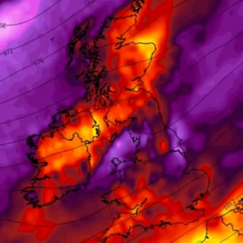
Detailed Impact and Regional Breakdown
Maps from WXCharts reveal the severity of the situation, showing the wind system arriving from the west and picking up throughout the day. It is expected to hit Northern Ireland first this morning before spreading to Wales, Scotland, and England. The most intense winds are forecast for northern England at Newcastle, the Lake District, northern Wales at Snowdonia, and inland areas in the east like Cambridge, where speeds could reach as high as 111kph (68mph)—12mph above the gale-force threshold of 54mph.
Weather warnings for these intense winds, which maps indicate could continue until up to 12am, have been issued for numerous areas. The affected regions include:
- Central, Tayside & Fife: Angus, Clackmannanshire, Dundee, Falkirk, Fife, Perth and Kinross, Stirling
- East Midlands: Derbyshire, Lincolnshire, Nottinghamshire
- Grampian: Aberdeen, Aberdeenshire
- North East England: Darlington, Durham, Gateshead, Hartlepool, Middlesbrough, Newcastle upon Tyne, North Tyneside, Northumberland, Redcar and Cleveland, South Tyneside, Stockton-on-Tees, Sunderland
- North West England: Blackburn with Darwen, Blackpool, Cheshire East, Cheshire West and Chester, Cumbria, Greater Manchester, Halton, Lancashire, Merseyside, Warrington
- SW Scotland, Lothian Borders: Dumfries and Galloway, East Lothian, Edinburgh, Midlothian Council, Scottish Borders, West Lothian
- Strathclyde: East Ayrshire, East Dunbartonshire, East Renfrewshire, Glasgow, North Ayrshire, North Lanarkshire, South Ayrshire, South Lanarkshire
- Wales: Conwy, Denbighshire, Flintshire, Gwynedd, Isle of Anglesey, Wrexham
- West Midlands: Staffordshire
- Yorkshire & Humber: East Riding of Yorkshire, Kingston upon Hull, North East Lincolnshire, North Lincolnshire, North Yorkshire, South Yorkshire, West Yorkshire, York
These warnings highlight the extensive reach of the gale-force winds, with the potential for significant disruption to daily life and infrastructure. The heavy wind could persist well into Friday, even after the official warnings end, according to the latest maps.
Broader Weather Context and Future Outlook
In addition to the wind, maps show that snow and heavy rain are set to accompany the severe conditions, exacerbating the challenges for residents and emergency services. The Met Office's forecasts align with earlier predictions of wintry weather, including snow flurries as far south as Devon and Cornwall in the coming days. This current system underscores the volatile nature of UK weather patterns, with climate factors potentially playing a role in such extreme events.

As the UK endures this bout of severe weather, authorities urge the public to stay informed through official channels and take necessary precautions. The combination of high winds, rain, and possible snow requires heightened awareness to ensure safety and minimize the impact on travel and utilities. With the situation evolving, further updates from the Met Office are anticipated as the weather front progresses southeastwards across the country.