The UK could be hit with a fresh wave of hot weather in July, just weeks after temperatures of nearly 40C brought the country to a standstill. According to new weather maps from WXCharts, the mercury is set to shoot back up to 29C in early July.
Brief Relief Before Heat Returns
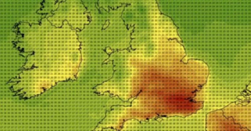
Britain will continue to reel under record-breaking June heat of nearly 40C until Sunday, when conditions are expected to become cooler. However, relief from the weather that has seen schools closed and public transport disrupted will only be temporary, forecasts from WXCharts predict.
The week from June 29 to July 5 will be characterised by slowly rising temperatures, averaging around 24C in parts of south and central England, maps from the online forecaster show. By the evening of July 8, the mercury will re-enter heatwave territory, with highs of 29C in the southwest.

Mid-July Forecasts
Forecasts for mid-July show temperatures holding steady at around 30C, indicating another period of hot and humid weather that could wreak fresh havoc on public services. It could also see the Met Office issue another rare red weather warning, indicating a risk to life even for the healthy population.
The warning was issued between Wednesday, June 24, and Friday, June 26, this week as consecutive days broke the record for the hottest monthly temperature on record.
Met Office Long-Range Outlook
The Met Office's long-range forecast also suggests there will be a brief dip in temperature as June transitions into July, before high pressure patterns mean "a greater chance of settled and drier than average conditions" next month. The Met Office's forecast for July 10 onwards says: "Temperatures are likely to be above normal on the whole, with a greater than normal chance of hot conditions developing at times."
While southern England is the region most likely to feel the impact of rising temperatures in July, northern parts of the UK will also see a drop to the low teens in the next week before rising back up to around 20C. Forecasts for mid to late July also warn of potential "changeable or unsettled conditions" with a risk of "heavy and thundery showers".