Met Office weather maps indicate that snow could fall across parts of England, Wales and Scotland early next week, with some wintry showers also expected this weekend.
The national weather agency had already warned that “hill snow” was possible on Monday and Tuesday, but the latest charts suggest the flurries may be more widespread than initially thought.
Snow Arrives in Wales and Northern England
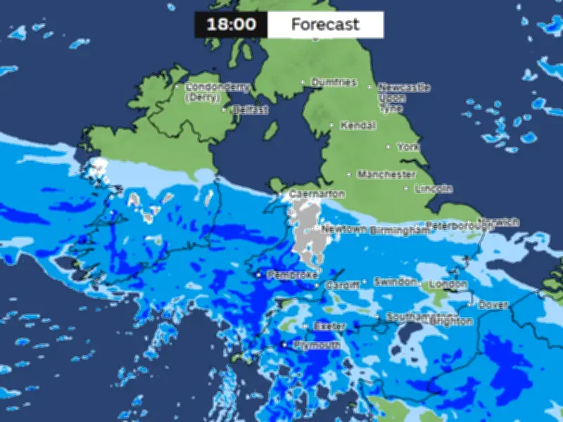
According to the Met Office charts, snow is first shown arriving in Wales at around 6pm on Monday, while rain falls across most of southern and central England. The snow is expected to be most intense over hills in North Wales.
By 9pm, the maps show snow drifting over the north-east, possibly reaching parts of Yorkshire as well as northern parts of Nottinghamshire and Derbyshire. By midnight, snow is shown falling over most of North Wales and northern England.
Wintry Conditions Spread to Scotland
The wintry conditions are tracked to reach areas around the Scottish borders in the early hours of Tuesday morning. Most of the snow will have subsided by around 9am, the data suggests.
More snow is expected before Monday, with the Met Office saying “some rain and hill snow” is on the cards in Scotland on Saturday, although conditions will be “largely fine and dry” elsewhere in England and Wales.
Context of Sudden Stratospheric Warming
This follows what BBC Weather has described as the “earliest major sudden stratospheric warming (SSW) on record”, as winds spiralling above the Arctic have shifted from their typical westerly direction to easterly.
Following SSW events, “these changes can slowly filter lower down in the atmosphere altering the position of the jet stream which drives what type of weather we experience on the ground”, the BBC explained.
SSW events often lead to cold snaps taking hold in the UK, and can also “boost the possibility of snow, especially across eastern parts of the UK”. The previous earliest major SSW event on record happened on November 28 in both 1969 and 2025.
However, forecasters say the cold snap this week comes as a result of developments in the troposphere, the lowest layer of the atmosphere, rather than the stratosphere.
Counties Affected
The 20 counties facing snow on Monday and Tuesday are:
- England: Shropshire, Herefordshire, Staffordshire, Cheshire, Derbyshire, Nottinghamshire, Lancashire, Yorkshire, Cumbria, Durham, Northumberland
- Wales: Caernarfonshire, Denbighshire, Merioneth, Montgomeryshire, Cardiganshire, Radnorshire, Flintshire
- Scotland: Dumfriesshire, Roxburghshire
The Met Office outlook for 6pm on Monday shows the initial snow in Wales, with the system moving north-east through the night before easing by Tuesday morning.