
Met Office Issues Yellow Rain Alert for South-West England as Flooding Threat Intensifies
The Met Office has warned that further rainfall could significantly worsen flooding conditions across south-west England in the aftermath of Storm Chandra. A yellow rain alert has been activated for Cornwall, Devon, Dorset and Somerset, effective from Monday afternoon through to Tuesday morning, with meteorologists cautioning that properties remain at risk.
Rainfall Warning Details and Timing
According to the national weather service, the warning period runs from 12pm on Monday until 9am on Tuesday. Meteorologist Jonathan Vautrey explained that a band of rain will gradually push northwards from the South West throughout Monday afternoon, initially affecting the Isles of Scilly and Cornwall before spreading to Devon, Somerset and Dorset later in the day and overnight.
"We're expecting widespread rainfall of 10 to 20 millimetres across the region," Mr Vautrey stated. "However, over elevated areas like Dartmoor, we could see significantly higher totals of 50 to 60 millimetres due to the already saturated ground conditions."

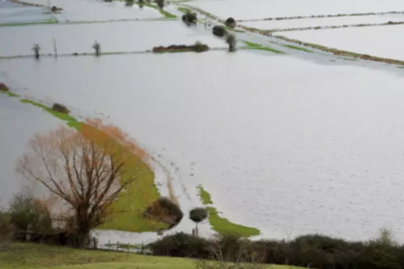
Exacerbating Existing Flood Impacts
The forecaster emphasised that while the predicted rainfall amounts may not reach the extremes of previous events, their impact will be magnified by the already waterlogged landscape. "Because this rain is adding to all the precipitation we've experienced recently, it has the potential to worsen existing flooding impacts," Mr Vautrey cautioned from the Met Office headquarters in Exeter.
He described observing waterlogged fields, high river levels, and generally damp conditions throughout the region, noting that any additional rainfall increases the likelihood of further disruption and property damage.
Transport Disruption and Safety Concerns
The anticipated rainfall is expected to cause significant difficulties on road networks and affect public transport services across the affected counties. The Met Office has warned that fast-flowing or deep floodwater could present a genuine danger to life, with some communities potentially becoming isolated due to flooded access routes.
"If your property is at risk of flooding, it's essential to take appropriate precautions and remain vigilant," Mr Vautrey advised residents in vulnerable areas.
Additional Weather Warnings Across the UK
Separately, the Met Office has issued a yellow ice alert for south-west England, parts of Hampshire, Wales and Northern Ireland, effective from 10pm on Sunday through to 9am Monday. This warning advises road users to exercise caution due to potential ice patches on untreated surfaces as temperatures drop overnight.
Mr Vautrey explained that Northern Ireland could experience temperatures as low as minus 2C to minus 4C, with residual water from Sunday's rainfall likely to freeze and create hazardous conditions. Meanwhile, eastern regions may see daytime temperatures around 5C due to cloud cover, with most areas experiencing seasonal temperatures of 6C to 9C.
Current Flood Situation and Response
As of Monday morning, 57 flood warnings remain in force across England, predominantly concentrated in Somerset, Dorset and Wiltshire, alongside 119 flood alerts nationwide. This follows a major incident declaration in Somerset earlier in the week when approximately 50 properties were affected by Storm Chandra-related flooding.
On the Somerset Levels, ultra high-volume pumps continue operating to remove flood water, with the major incident status remaining active. Somerset Council has warned that additional rainfall could lead to further property flooding in the Moorland, Saltmoor and Currymoor areas.
The Environment Agency reports that water levels in the River Tone have stabilised, with the Parrett flood relief channel now open to facilitate drainage of excess water. Additional contingency pumps have been installed at Aller Drove and Westonzoyland as precautionary measures against further flooding.

Broader Weather Patterns
The latest warnings follow a period of exceptionally wet weather throughout January, characterised by heavy rain, snow and storms. While north-eastern Scotland may experience some rain turning to snow over mountainous areas on Monday morning, the primary concern remains focused on the south-west of England where saturated ground cannot absorb additional precipitation effectively.


