Controversial plans for up to 258 new homes on land off Green Lane in Maghull have moved to the next stage after the applicant submitted an application for an environmental impact assessment opinion from the council.
Objections were raised by councillors across the political spectrum and local MP Bill Esterson when Anwyl Homes submitted a speculative proposal to build on the green belt site, which is not in Sefton’s existing Local Plan. Anwyl already has planning permission to build part of the Poverty Lane to School Lane development called Land East of Maghull, which covers 85 hectares and has space for 1,400 homes.
MP and Councillors Voice Opposition
Mr Esterson argued: “They should focus on finishing the building there, not on causing upset elsewhere as they have done with their Green Lane proposal. We need new homes across the UK but these should be built first where there is brownfield land and where planning permission has already been given.”
Maghull and Lydiate have already seen significant development in recent years, with estates like Eastbrook Village, Summerhill Park, Poppyfields and Lydiate Gate.
Environmental Impact Screening Requested
Anwyl has now submitted an environmental impact assessment screening opinion application, which is a request for a formal decision from Sefton Council on whether the proposed development requires a full assessment. The application includes a green belt review considering whether the land could be seen as “grey belt,” therefore making it acceptable to build on it.
Under the Labour Government’s National Planning Policy Framework, adopted in December 2024, land can be classed as grey belt land if it is of low ecological value and makes little contribution to the aims of the green belt.
Site Location and Green Belt Assessment
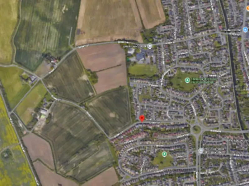
The proposed site lies to the edge of Maghull on agricultural fields off Green Lane, which wraps around from the north, south and west. There are already some residential properties to the east on West Meade and Stangate, as well as St John Bosco Catholic Primary School and St James’ Church. It is in the green belt but not within a conservation area, and the applicant noted that it lies immediately adjacent to the west of Maghull, suggesting that this makes it a “logical extension to the settlement rather than forming part of the wider open countryside”.
The applicant’s proposals have been assessed against the purposes of the green belt, which include preventing the unrestricted sprawl of built-up areas, stopping neighbouring towns from merging and preserving the character of historic towns. With regards to the first purpose, the architect reviewing the proposals said that land making a strong contribution to the green belt would be completely free of existing development, and would not have features that would enable any development to be contained. It therefore judged that because the site is already adjoining Maghull and with housing on one side, it has a “limited relationship with the wider open countryside and does not materially contribute to the unrestricted sprawl of the adjacent settlement”.
In relation to stopping towns from merging, the architect said that for a site to make a strong contribution it would be free from existing development and form a substantial part of the gap between settlements. The architect added that the proposed site is 6.25km from Hightown to the west and 2.5km from Thornton to the south west, and that there is open countryside separating these settlements from Maghull. Finally, in terms of preserving the special character of a historic town, the architect said that a site must make a significant contribution to the setting, such as being of visual importance. It judged that the proposed development site is not located within a historic town and that there are no designated cultural or heritage assets within the surrounding areas that rely on the site remaining open green belt land.
The site does contribute moderately to one green belt purpose, to assist in safeguarding the countryside from encroachment, but the assessment said that in terms of the other purposes its role is limited. The architect therefore stated that the land can be judged as “grey belt,” meaning that development would be a “logical and contained extension to the existing settlement”.
Proposed Features and Consultation
Anwyl has also said that it would incorporate play areas, open space and new pedestrian routes into its development, which would “improve connectivity to the surrounding public rights of way network”. It added that it would retain key landscape features like existing boundary hedgerows, mature trees and ponds. Under the current plans, the primary access point to the site for cars would be via an extension to West Meade, with secondary access provided off Green Lane to the south, which may be widened slightly.
This application is now in the consultation period, with neighbours able to submit comments until August 4. The application can be found on the Sefton Council planning portal under the reference DC/2026/01232.