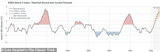
Experts have warned that a 'super El Niño' could develop this summer, with a 62 per cent chance of a switch from the current La Niña phase occurring between June and August. There is a 15 per cent chance it could become a super El Niño by November, which would be only the third such event in the last 30 years.
The El Niño–Southern Oscillation (ENSO) is a climate pattern involving warm and cool water in the equatorial Pacific. During a typical El Niño, ocean temperatures rise at least 0.5°C above the long-term average, while a super El Niño requires a rise of at least 2°C. The most recent super event was in 2015–2016.
Climate scientist Zeke Hausfather said: 'If a strong El Niño develops, it would push up 2026 global temperatures and particularly 2027 temperatures. 2027 would be increasingly likely to be a record warm year.' The hottest year on record is currently 2024, which coincided with an El Niño event and saw global average temperatures exceed 1.5°C above pre-industrial levels for the first time.
El Niño events can trigger heavier winter rains in California, deeper droughts in Australia, and a greater risk of wildfires in Southeast Asia. Experts have also warned that by 2060, the ENSO cycle could shift to a regular frequency of every two to five years, leading to back-to-back years of flooding and drought, known as climate whiplash.