Super El Nino Warning: Brace for Record Heat and Global Chaos
Super El Nino: Brace for Record Heat and Chaos

There is definitely something coming. We are very confident about that, and it looks like it will be a big event, said Adam Scaife, head of long-range prediction at the UK Met Office. He was referring to a potential approaching El Nino, possibly so strong it may be classified as a super El Nino, and warned it could even be of record strength.

What is El Nino?

The El Nino effect is a natural, cyclical climate pattern in the Pacific Ocean, characterised by the warming of surface ocean temperatures in the central and eastern equatorial Pacific. Under normal conditions, trade winds blow westward along the equator, pushing warm water from South America towards Asia; cold water rises from below to replace this warmer water in a process known as upwelling. But El Nino throws all that into disarray. Trade winds are not as strong, and so the warm waters head east towards the Americas instead, forcing the Pacific jet stream south of its neutral position. Upwelling weakens or stops altogether; without the nutrients being transported from the depths to the shallows of the ocean, there are fewer phytoplankton off the coast, which in turn impacts fish that eat phytoplankton, which in turn impacts everything that eats fish. Entire ecosystems are disrupted by the change.

Some areas in the northern US and Canada become hotter than usual and experience droughts; the US Gulf Coast and southeast experience wetter weather than usual, and increased flood risk.

Wide Pickt banner — collaborative shopping lists app for Telegram, phone mockup with grocery list

Global Impact

But El Ninos impact is far wider than just the Americas: they change weather on a global scale. Countries around the tropical Pacific, like Chile and Indonesia, are strongly affected, with the former more likely to get heavy rainfall and the latter more likely to suffer droughts. We could see an extreme Pacific typhoon season and a more docile hurricane season in the Atlantic, a much more varied and unpredictable South Asian monsoon season, and a drier-than-normal Australia.

UK Specifics

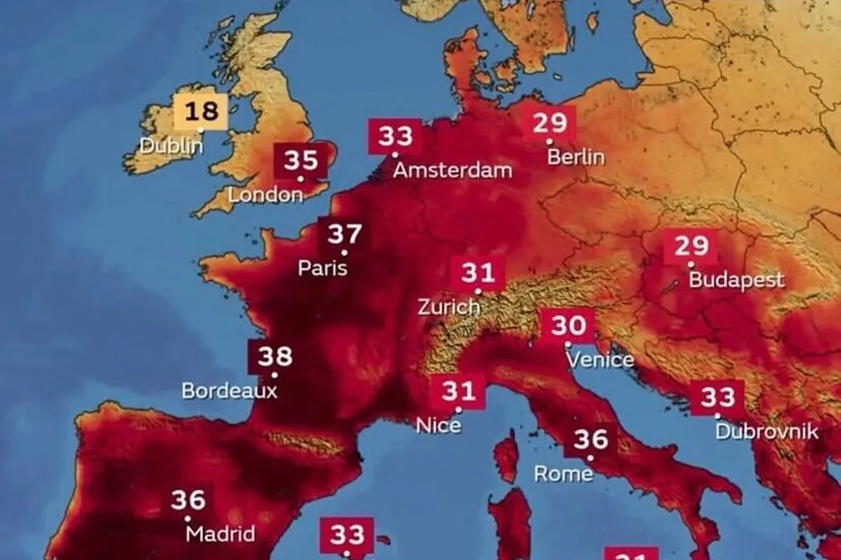
In the UK specifically, the El Nino effect is usually weaker but can lead to more dramatic weather extremes: winter temperatures tend to be colder, especially later in the season, while in summer the mercury soars. This current heatwave might prove the tip of the iceberg. Summer temperatures could certainly be impacted, possibly this year, but more likely next, as the planet heats up, says Professor Bill McGuire, Emeritus professor of geophysical and climate hazards at University College London and author of the new book The Fate of the World: A History and Future of the Climate Crisis. I would not be at all surprised to see 40°C-plus heat.

What Makes a Super El Nino?

What tips an El Nino into super territory is all to do with water temperature. If sea surface temperatures there are more than 0.5°C above normal for the time of year, we say that those are El Nino conditions, according to Mark Roulston, senior research fellow and director of operations for Lancaster Universitys Climate Risk and Uncertainty Collective Intelligence Aggregation Laboratory (Crucial). A Super El Nino is often defined as when these temperatures are more than 2°C above normal for the time of year, so a more extreme version of the El Nino phenomenon.

Ocean warming has been rapid over the past few weeks and is expected to continue over the next few months, peaking in autumn. While El Nino conditions can sometimes last for as long as 18 months, the more extreme conditions associated with a Super El Nino tend to be shorter-lived, more in the region of two to four months.

Pickt after-article banner — collaborative shopping lists app with family illustration

Current Predictions

Crucials predictions currently indicate that there is a more than 85 per cent chance of El Nino conditions prevailing during the upcoming winter (December, January and February), and around a 45 per cent chance that the conditions will be extreme enough to be classed as a Super El Nino. The National Oceanographic and Atmospheric Administration (NOAA), which forecasts that El Nino will begin within the month, has crunched the numbers and given a 66 per cent chance that it will be strong or even very strong by this winter. More than half of the European Centre for Medium Range Weather Forecasts (ECMWF)s models, meanwhile, are suggesting a potential ocean temperature increase of over 2.5°C by the autumn, putting it well within super range. There is growing confidence from scientists that this potential El Nino could be notably strong.

My personal opinion is that we will see the 2.5°C threshold broken, and may even approach 3°C, challenging the strongest El Nino on record in 1877-8, advises Professor McGuire.

While organisations around the world have their own exact definitions and thresholds for what constitutes El Nino conditions, this will be such a significant event, if it happens, that it will be above all of those thresholds and there will be no doubt that we are in an El Nino, said Grahame Madge, climate science communicator at the Met Office. Scientists are telling us that this could be the strongest El Nino event so far this century, comparable to the notable El Nino event in 1998.

Historical Context

While significant El Ninos occur around every two to seven years, Super El Ninos are rare. Only three others have exceeded the 2°C threshold since the mega one recorded in 1877-8: 1982-3, 1997/8 and 2015-16. This latest El Nino could see 2027 become the hottest year on record, pushing global average temperatures permanently past the benchmark of 1.5°C above pre-industrial levels set by the Paris climate agreement.

Humanitarian and Environmental Consequences

While having a roasting summer might sound appealing to some, Super El Ninos tend to result in widespread humanitarian, as well as environmental, disaster: food shortages and famine due to severe droughts; an increased risk of devastating floods and wildfires. The 1997/8 Super El Nino resulted in the death of an estimated 16 per cent of all the worlds coral reefs.

You have got more people that are living in poverty already and if you get a reduction in crop yields because of drought or flooding [from El Nino] then that drives prices even higher, Liz Stephens, professor of climate risk and resilience at the University of Reading, told the BBC. So we are looking at potentially quite huge humanitarian impacts this year, especially if the crisis in the Middle East continues.

Climate Change Connection

The effects of El Nino events are exacerbated further by an ever-warming planet, compounding the impacts of climate change. Super variants can have such a huge warming effect that temperatures for many years following are notably cooler. This has been used as evidence by some climate change deniers in the past; for example, after the 1997-8 Super El Nino, global temperatures did not reach the same level until 2014, which caused some people to declare that global warming was over, explains Roulston. However, since 2014, global temperatures have continued to climb, surpassing the 1997-8 El Nino-fuelled record. If we have another Super El Nino the same thing is likely to occur, with subsequent years being cooler than the spike associated with the event, Roulston adds. I have no doubt that again some people will argue this means global warming has stopped, but it is a statistical illusion caused by picking a record year as your baseline.

It is why adapting to El Nino weather should be part of a general adaptation programme aimed at limiting the severe impacts of living in a much hotter world, according to McGuire. The reality is that our climate is on track to reprise conditions in the Pliocene period, 3 million years back, 3°C-plus higher temperatures, and, eventually, sea level 15 to 25 metres higher, he warns. And that is the BEST case.