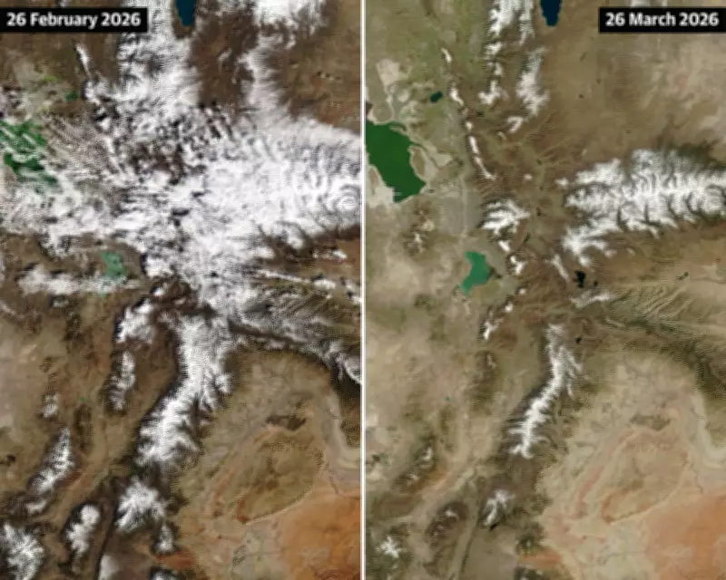
NASA Satellite Images Capture Alarming Snowpack Decline in Utah
NASA satellite images have starkly illustrated the rapid diminishment of snowpack in Utah between late February and late March, revealing a troubling trend that has left scientists deeply concerned. The visual evidence underscores a broader crisis across the American West, where a historically warm winter and searing March temperatures have driven snowpack to record-low levels.
Unprecedented Melt-Off Stuns Climate Experts
Snow surveys conducted across the American West this week paint a grim prognosis. Experts warn that the stunning pace of melt-off over the past month has left key basins in uncharted territory for the upcoming dry seasons. Despite potential for more snow in the forecast, it is likely to be too little, too late to mitigate the damage.
"This year is on a whole other level," said Dr. Russ Schumacher, a climatologist at Colorado State University, referring to the intense heat that rapidly melted the already sparse snowpack in March. "Seeing this year so far below any of the other years we have data for is very concerning."

Snowpacks act as a critical water savings account, essential for water supply. Measurements taken during the week of April 1st serve as important indicators of the peak water amounts that will melt into reservoirs, rivers, and streams through the summer.
California's Sierra Nevada Faces Dire Conditions
During a critical survey in California's Sierra Nevada, state officials found grass and mud visible through thin white patches as they attempted to measure the meager snowpack. Andy Reising, manager of the California Department of Water Resources' snow surveys and water supply forecasting unit, noted that the typical 5-foot-tall tool used for measurements poked into brown earth instead of deep snow berms.
"There is actually no measurable snow," Reising said, highlighting that this year's annual April snow survey at Phillips Station was the second worst on record, surpassed only by 2015. The concern extends beyond snow depth to "snow water equivalent" (SWE), a measurement of moisture that could melt to supply natural and manmade systems, which is exceptionally low.
California's Sierra Nevada had just 4.9 inches of SWE, or 18% of average, while the Colorado River headwaters—supplying over 40 million people, 5.5 million acres of agriculture, 30 tribal nations, and parts of Mexico—had just over 4 inches of SWE, or 24% of average. This is less than half of what was previously considered the record low.
Widespread Impacts Across the Southwest
Data from the U.S. Department of Agriculture shows alarming lows across the Southwest and Intermountain West. The Great Basin had only 16% of average SWE, the lower Colorado region was at 10%, and the Rio Grande basin was at 8%. Dr. Schumacher emphasized that snow water equivalent measurements entering April were at levels typically seen in May or June, after months of melt-off.
"This year has the potential of being way worse than any of the years we have analogues for in the past," Schumacher warned, noting that an incoming storm might slow melting but won't pull basins back from the brink.
Record Heat Fuels Rapid Melt
March brought a blistering heatwave unlike any recorded for the season, with over 1,500 monthly high temperature records broken. Climate scientist Daniel Swain described the event as "likely among the most statistically anomalous extreme heat events ever observed in the American Southwest." He noted that the heat has decimated the snowpack across nearly all of the American West, with California tied for its worst mountain snowpack value on record.
Karla Nemeth, director of the California Department of Water Resources, remarked, "It feels like we skipped spring this year and dropped straight into a summer heatwave." The rapid melt has left lower slopes completely bare nearly statewide, with potential for the earliest melt-off on record.

Water Supply and Fire Season Concerns
The fast-melting snow threatens drinking water supplies, agriculture production, and outdoor recreation. In the Colorado River Basin, reservoirs like Lake Mead and Lake Powell are only 25% and 33% full, respectively, with little snowpack to replenish them. Officials are already relocating a floating marina on Lake Powell in anticipation of receding water levels, raising fears of "deadpool" conditions where dams cease to function.
Municipalities are responding with early water restrictions. Salt Lake City has called for conservation efforts to cut up to 10 million gallons, while Colorado and Wyoming have implemented limits on lawn watering. Farmers and ranchers face hard decisions with smaller water allocations.
The situation also sets the stage for an extended fire season. Dr. Joel Lisonbee, a senior associate scientist at the University of Colorado Boulder, warned that landscapes typically protected by snow will dry out faster, leading to fire seasons starting weeks to months earlier. Over 1.5 million acres have already burned this year, more than double the 10-year average.
Climate Change Exacerbates Extreme Events
Experts link these trends to climate change, which is fueling warming that leaves the West hotter and drier. Dr. Abby Frazier, a climatologist at Clark University, emphasized that compound events, such as heat and drought occurring together, are on the rise and will produce greater dangers from fire.
"It is heartbreaking to see it all playing out as we have predicted for so long," Frazier said. "The changes we have teed up for ourselves are going to be catastrophic." She called for transformative action, prioritizing adaptation and mitigation to address the escalating crisis.