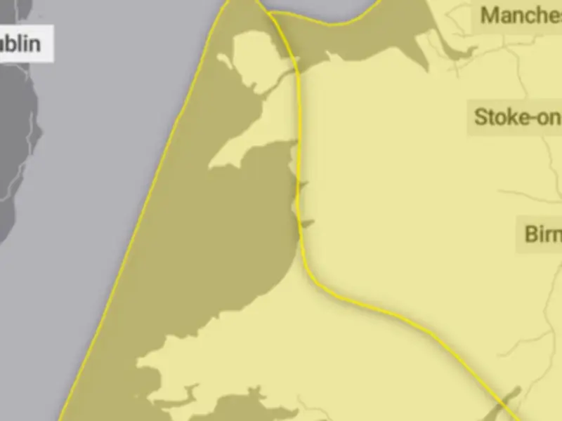
The Met Office has updated its weather warnings for this week, now covering the whole of Wales as strong winds are set to cause disruption, with two yellow weather warnings in place. From midnight to 9pm on Friday, October 23, areas across Wales will see Storm Austen bring winds of 70mph or over, with a danger to life warning also issued.
An initial yellow warning for parts of south and west Wales for Friday has now been extended, lasting until 5pm and covering more of the country. A second yellow warning for wind has been issued for the rest of Wales, mainly mid and North Wales, for Friday from 10am until 9pm.
Warnings and affected areas
The Met Office warnings state: "Strong west to northwesterly winds will spread across southern parts of England and Wales during Thursday night and into Friday. Gusts of 50-60 mph are likely and some coastal or exposed areas could see 70 mph or more, this more likely over parts of southwest England."
Ahead of this, a spell of southerly winds with gusts of 50-60 mph will move east along the south coast of England during Thursday night. Winds will slowly ease during Friday afternoon. Strong winds will be also combined with periods of heavy rain making for difficult travel conditions.
"Whilst the winds across the warning area are not expected to be as strong as those further south and west, a spell of inland gales is possible with gusts around 45 to 55mph during Friday daytime. In combination with locally heavy rain and many trees still in full leaf, there is potential for some power outages and travel disruption."
The yellow wind warning from midnight to 5pm on Friday includes Blaenau Gwent, Bridgend, Caerphilly, Cardiff, Carmarthenshire, Ceredigion, Gwynedd, Isle of Anglesey, Merthyr Tydfil, Monmouthshire, Neath Port Talbot, Newport, Pembrokeshire, Powys, Rhondda Cynon Taf, Swansea, Torfaen, and Vale of Glamorgan.
The yellow wind warning from 10am to 9pm on Friday includes Ceredigion, Conwy, Denbighshire, Flintshire, Gwynedd, Isle of Anglesey, Monmouthshire, Powys, and Wrexham.
Danger to life and safety advice
For south and west Wales, the Met Office has warned of a danger to life alert, advising people to prepare their properties and protect themselves from the storm. The forecaster has stated: "Injuries and danger to life from flying debris are possible. Injuries and danger to life could occur from large waves and beach material being thrown onto sea fronts, coastal roads and properties."
Damage to buildings is also possible, as well as disruption to travel. Road, rail, air and ferry services may be affected, with longer journey times and cancellations possible along with road closures.
The Met Office has given advice for people to stay safe during gale-force winds. It advises: "Prepare to protect your property and people from injury. Check for loose items outside your home and plan how you could secure them. Items include: bins, garden furniture, trampolines, tents, sheds, and fences."
"Give yourself the best chance of avoiding delays by checking road conditions if driving, or bus and train timetables, amending your travel plans if necessary. People cope better with power cuts when they have prepared for them in advance. It's easy to do; consider gathering torches and batteries, a mobile phone power pack and other essential items."
"If you are on the coast, stay safe during stormy weather by being aware of large waves. Even from the shore large breaking waves can sweep you off your feet and out to sea. Take care if walking near cliffs; know your route and keep dogs on a lead. In an emergency, call 999 and ask for the Coastguard."
Be prepared for weather warnings to change quickly. When a weather warning is issued, the Met Office recommends staying up to date with the weather forecast in your area.