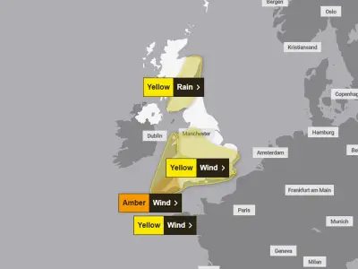
The Met Office has issued three weather warnings for Storm Boelo, covering 70 areas across the UK, with gusts of at least 80mph expected. The warnings, which span Saturday and Sunday, all state that power cuts could hit affected areas, and the forecaster is urging people to prepare in advance by "gathering torches and batteries, a mobile phone power pack and other essential items".
Storm Austen is currently battering the UK, with flood warnings in place in southern areas. Brighton's iconic West Pier has partially collapsed and wind speeds have climbed over 100mph. More weather chaos is expected this weekend as Storm Boelo arrives, described by the Met Office as being "invigorated by an active jet stream" before reaching the UK.
Amber wind warning for Saturday and Sunday
An amber warning for wind will be in place between 9pm on Saturday and 9pm on Sunday, covering 34 areas in Scotland, England and Northern Ireland. The Met Office says the strongest Storm Boelo winds are expected from Saturday evening and will extend eastwards through Sunday.
The forecaster said: "Very strong westerly winds associated with Storm Boelo are expected with fairly widespread gusts of 60 to 70mph and gusts to 80mph in exposed coastal areas." The winds will be accompanied by heavy rain and will gradually ease from the west through Sunday.
All three warnings state there is a risk of flying debris, power cuts and damage to buildings. Travel disruption is also expected, with the Met Office adding that "injuries and danger to life are likely from large waves and beach material being thrown onto coastal roads, sea fronts and properties".
Yellow warnings for Northern Ireland, England and Scotland
A yellow wind warning is in place for Northern Ireland from 10am on Saturday to midday on Sunday, with gusts potentially reaching up to 75mph in exposed coastal regions. The warning states: "Strong winds will spread across Northern Ireland during Saturday. Initially strong southerly winds will develop on Saturday morning, before stronger westerly winds follow later in the day. Very windy conditions will persist overnight and into Sunday before gradually easing from the southwest during Sunday morning. Gusts of 50-60mph are likely widely with some coastal and exposed areas potentially seeing gusts of 65-75mph. Strong winds will be combined with blustery heavy showers."
Another yellow weather warning covers Scotland, northern parts of northern England and the Midlands between midday on Saturday and 9pm on Sunday, carrying the same risks of power cuts, flying debris, travel chaos, and danger to life from waves or beach material being thrown onto seafronts. The Met Office said: "Initially strong southerly winds will affect parts of Scotland before more widespread and even stronger westerly winds develop later on Saturday. Very windy conditions will then persist overnight and through much of Sunday before gradually easing from the southwest later. Gusts of 55-65mph are likely widely with some coastal and exposed areas potentially seeing gusts of 70-80mph or more, these strongest gusts most likely across Scotland and the far north of England."
Safety advice and affected areas
The forecaster warns driving in these conditions can be dangerous and that motorists should drive slowly to minimise the impact of wind gusts. The amber warning adds: "Being outside in high winds makes you more vulnerable to injury. Stay indoors as much as possible. If you do go out, try not to walk, or shelter, close to buildings and trees. In advance of high winds, check for loose items outside your home and secure them. Items include: bins, garden furniture, trampolines, tents, sheds, and fences."
The amber warning covers 34 areas including Angus, Clackmannanshire, Dundee, Falkirk, Fife, Perth and Kinross, Stirling, Aberdeen, Aberdeenshire, Moray, Na h-Eileanan Siar, Highland, Northumberland, Cumbria, County Antrim, County Londonderry, Argyll and Bute, East Ayrshire, East Dunbartonshire, East Renfrewshire, Glasgow, Inverclyde, North Ayrshire, North Lanarkshire, Renfrewshire, South Ayrshire, South Lanarkshire, West Dunbartonshire, Dumfries and Galloway, East Lothian, Edinburgh, Midlothian Council, Scottish Borders and West Lothian.
The yellow warning for Northern Ireland covers County Antrim, County Armagh, County Down, County Fermanagh, County Londonderry and County Tyrone. The yellow warning for England and Scotland covers a wider area, including Derbyshire, Lincolnshire, Nottinghamshire, Darlington, Durham, Gateshead, Hartlepool, Middlesbrough, Newcastle upon Tyne, North Tyneside, Redcar and Cleveland, South Tyneside, Stockton-on-Tees, Sunderland, Blackburn with Darwen, Blackpool, Cheshire East, Cheshire West and Chester, Greater Manchester, Halton, Lancashire, Merseyside, Warrington, Orkney Islands, East Riding of Yorkshire, Kingston upon Hull, North East Lincolnshire, North Lincolnshire, North Yorkshire, South Yorkshire, West Yorkshire and York, along with many of the same areas listed in the amber warning. The winds are expected to gradually ease from the southwest during Sunday, bringing an end to the weekend's severe weather.