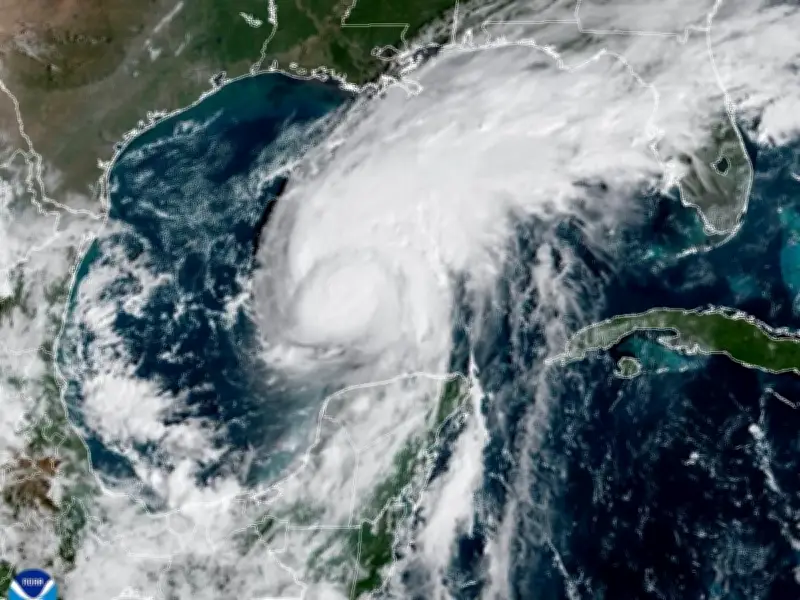
Hurricane Isaias, a Category 2 storm with maximum sustained winds of 105 mph (165 kph), is barreling toward the Gulf of Mexico coast, with landfall expected late Friday or early Saturday. The National Hurricane Centre has issued red alerts for Florida, Alabama and Mississippi, warning of dangerous conditions as the first hurricane of the Atlantic season intensifies rapidly.
Tourists and residents near the Florida coast have bolted inland, stocking up on essential supplies while fishing crews secure their boats. Heavy rain and flooding are possible into the weekend as far north as Tennessee and North Carolina.
Officials Urge Preparation as Storm Approaches
Michael Brennan, director of the National Hurricane Centre in Miami, said: “We are expecting Isaias to be a dangerous hurricane when it makes landfall. Thursday is the day to prepare and get ready and be in your safe place by tomorrow as conditions will rapidly deteriorate along the northern Gulf Coast as Isaias approaches.”
Isaias was headed northeast at 14 mph (22 kph) and was centred about 260 miles (415 kilometres) south of the mouth of the Mississippi River. A hurricane warning was in effect from Ocean Springs, Mississippi, to the Bay-Gulf County line in Florida, and a storm surge warning from the mouth of the Mississippi to the Suwannee River.
Evacuations and Emergency Declarations
At least four Florida school districts cancelled late-week classes, while several counties announced mandatory evacuations for some coastal areas. The governors of Florida and Alabama declared states of emergency for dozens of counties, with Florida’s Ron DeSantis saying about 5,000 National Guard troops were expected to mobilise by Friday.
On Dauphin Island, a 15-mile barrier island off the Alabama coast, officials encouraged voluntary evacuations, particularly on its popular western section, which is vulnerable to storm surge. Mayor Jeff Collier said he did not anticipate substantial damage, “but at the same time, these things are very fickle and a little jog here or there, or some last-minute increase in strength — we just have to be prepared for the worst.”
Storm Surge and Rainfall Forecast
Water from the storm surge and high tide could reach heights of 5 to 7 feet (1.5 to 2 meters) in parts of Alabama and Mississippi, forecasters said. Isaias also could dump up to 15 inches (38 centimeters) of rain on coastal areas and spawn tornadoes overnight Friday into Saturday from Alabama to the Florida Panhandle and southwestern Georgia. The hurricane is expected to quickly weaken after coming ashore.
The National Weather Service warned of possible “long-duration power outages.”
Record-Late Formation and Quiet Season
Isaias developed more than four months into the Atlantic hurricane season and was one day short of tying a 121-year-old record for the area’s latest-forming hurricane. That record dates to 1905, when the year’s first Atlantic hurricane formed on October 8.
The Atlantic hurricane season has been unusually quiet this year because of a strong El Niño, which disrupts storm formation over the Atlantic. Storm activity has been above average in the Pacific, where Hurricane Simon, which formed as a tropical storm on Wednesday off of Mexico and became a hurricane late Thursday, was forecast to strengthen into a Category 4 hurricane.
Further north, Tropical Storm Rachel was expected to reach Baja California, Mexico, and Southern California this weekend. Isaias is expected to strike a swath of coastline that’s familiar with major hurricanes. One of the 20th century’s worst storms, Hurricane Camille, killed more than 250 people after hitting land near Waveland, Mississippi, in 1969. Hurricane Katrina in 2005 razed neighborhoods in Mississippi, flooded New Orleans and killed nearly 1,400 people. Hurricane Michael leveled homes and buildings near Panama City, Florida, in 2018.