After a sweltering summer, rain is set to return to Wales towards the end of next week, just in time for the Bank Holiday weekend. The Met Office reports that the week will begin largely dry, with sunny spells and some cloud, and temperatures expected to feel slightly warmer, particularly in the sunshine, with maximum temperatures reaching around 24°C on Monday, August 24.
Forecaster warns of heavy rain
However, Mark Sidaway, Met Office deputy chief forecaster, said rain and showers will become increasingly widespread as warm, humid air spreads further north across the UK. Thunderstorms are likely to develop, particularly across England and Wales, before a more organised area of thundery rain approaches southwest Britain later in the day.
Mr Sidaway said: “As warmer and more humid air moves north across the UK, there is an increasing likelihood of some heavy rain developing.”

He added: “Some places could see 20 to 30mm of rain in just a few hours, while there is also the potential for higher totals where thunderstorms repeatedly affect the same locations. The details of which areas will see the heaviest rainfall are still uncertain.”
Wednesday’s rain arrival
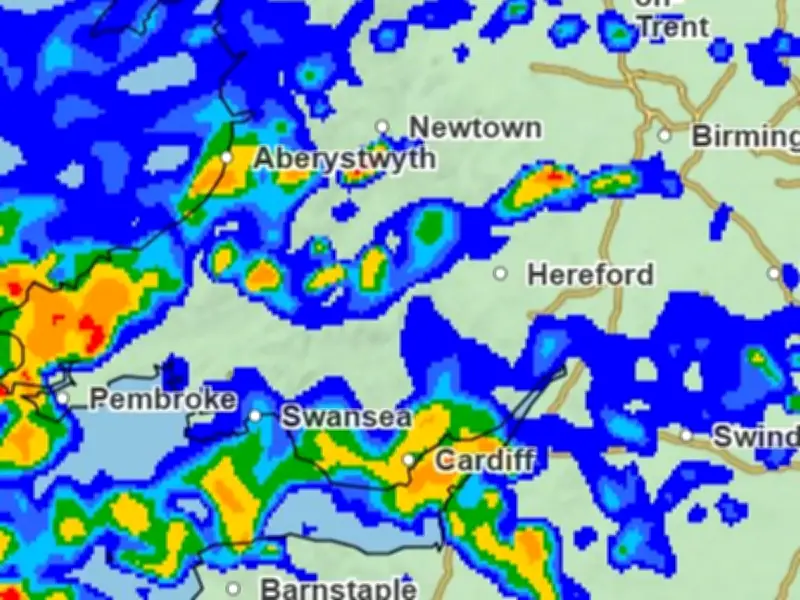
Weather maps indicate that rain will begin moving inland from the coast during the early hours of Wednesday (August 26) morning. By around 4am, some of the heaviest rain is expected to affect areas including Newtown, Ludlow and Hay-on-Wye. Along the coast, parts of Swansea, Pembrokeshire and Cardigan could also see periods of wet weather.
By around 7am, parts of North Wales look set to experience some of the heaviest rainfall, with Wrexham potentially seeing between 4mm and 16mm of rain per hour. Further south, scattered showers are expected, with Carmarthen and Merthyr Tydfil also likely to see some rain.
As the day progresses, the rain is expected to gradually clear. Some lighter patches of rainfall, ranging from around 0.5mm to 1mm, could remain scattered across parts of Wales before conditions become drier by the end of the day.
Thursday and Friday outlook
Thursday (August 27) is expected to see the rain return from around 4am, once again moving inland from the coast. Cardiff, Swansea, St Davids and Aberystwyth appear to be among the areas facing the heaviest rain during the morning, while Lampeter and Llanidloes could also experience bouts of wet weather.
The rain is then expected to push further north, affecting areas including Caernarfon, St Asaph and Bangor. By the afternoon, the wet weather looks likely to remain concentrated across northern parts of Wales. However, the area between Aberystwyth and Llanidloes could see particularly heavy rainfall, with some weather maps indicating rates of between 16mm and 32mm per hour.
As the week draws to a close, the unsettled weather looks set to continue, with weather maps showing rain covering large parts of Wales, stretching from Colwyn Bay through to Newtown, Builth Wells and Brecon. During the mid morning, Swansea, Neath Port Talbot and Merthyr look to be the driest areas, while Aberaeron and the area surrounding Builth Wells look to be experiencing the wettest.
As the day progresses, the rain is expected to push further towards the Welsh capital, Newport and Chepstow. By 4pm the rain looks to have cleared from the country, with Wales seeing mild weather and spells of sunshine.