The UK is set for a second storm in two days, with Storm Boelo expected to bring gusts of over 60mph from Saturday to Sunday, and up to 80mph possible further north in Scotland. A yellow weather warning has been extended across the North East for the weekend, following Storm Austen's impact on Friday.
Storm Austen Hits South and Scotland
Storm Austen is forecast to bring strong gusts and heavy rain to the south and south-west of England, and Scotland, until Saturday. An amber wind warning covers Cornwall, Devon and the Isles of Scilly for much of Friday morning, according to the Press Association. The Met Office warns of disruption on roads and public transport, flying debris, probable damage to buildings, and danger to life due to large waves in coastal areas.
Mobile phone coverage and power supply could also be affected. Chief forecaster Neil Armstrong said: "This is the first stormy weather in the south of the UK this season and we expect some disruption as it moves through." Heavy rain is expected, especially in southern and eastern Scotland, with 60-80mm of rain possible in some locations.
Storm Boelo to Bring Impactful Winds
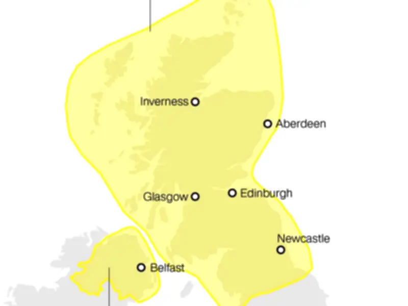
Storm Boelo will affect parts of northern England, Scotland and Northern Ireland over the weekend, with what the Met Office describes as "impactful winds". Yellow weather warnings have been issued for the far north of England, the whole of mainland Scotland, the Western Isles and Orkney from 6pm on Saturday to 9pm on Sunday. A separate yellow warning covers Northern Ireland from 6pm on Saturday to 3pm on Sunday.
Widespread gusts of 55-65mph are expected, reaching up to 70-80mph in exposed coastal locations. Met Office deputy chief forecaster Chris Bulmer said: "Storm Boelo will bring strong winds and heavy rain to northern Ireland, Scotland and parts of northern England over the weekend, impacting the opposite end of the country to Storm Austen. Gusts of 70-80mph in exposed coastal areas and high ground are possible, with 50-60mph gusts more widely."
Travel Disruption and Safety Advice
Rail services are affected, with Network Rail Scotland saying trains will be slowed down on Friday and over the weekend to keep people safe. Southern Rail announced early on Friday that a service was disrupted by a lightning strike. National Rail reported that fewer trains would be stopping at an Isle of Wight station due to the weather, and some services in the north will be changed throughout Friday, advising passengers to plan ahead. Some services between Leeds and York via Harrogate will not stop at Weeton or Headingley, while trains between York and Blackpool North will skip New Pudsey.
Garth Smith, head of resilience at the British Red Cross, urged people to keep an eye on local weather reports and take guidance from local authorities. He said: "We have practical advice that can make a real difference - from checking in with people who may be more vulnerable, securing loose items in your garden to checking windows and doors, and making an evacuation plan for your household, including pets." Greenpeace climate campaigner Maja Darlington called on the Government to act to stop a "doomloop of extreme weather", saying: "We've barely cooled off from a summer of blistering heat, and now the first winter storms are battering at the front door."