
The Bureau of Meteorology has escalated emergency warnings across Central Queensland, as a surge in flood rescues compels police to issue urgent public advisories. Queensland Police executed multiple life-saving operations on Monday, extracting individuals from the roofs of their vehicles after intense overnight rainfall sparked widespread flash flooding throughout the region.
Dramatic Rescues Amid Rising Waters
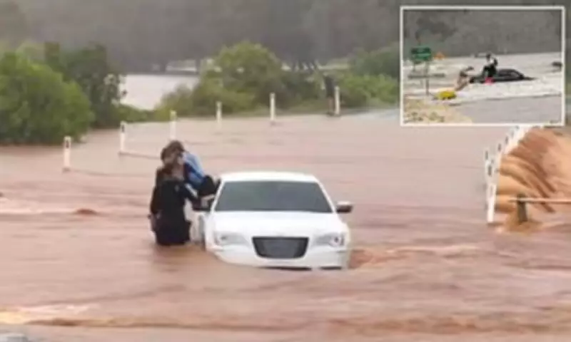
Shocking footage captured officers rescuing a young child from a car ensnared by floodwaters on The Causeway in Bargara, located approximately 15 kilometres east of Bundaberg. In an official statement, Queensland Police confirmed, "Around 7.40am, police located the vehicle and officers were able to safely remove both occupants. No injuries were reported." The force reiterated its critical safety message for flood emergencies: If it's flooded, forget it.
Fines and Dangers for Motorists
Authorities reminded motorists that driving through floodwaters not only risks vehicle loss but also incurs substantial penalties. Police disclosed that "the driver of the vehicle, a 54-year-old Bundaberg man was also issued a $667 fine for driving without due care and attention." This incident underscores the severe consequences of ignoring flood warnings.

Extensive Weather Warnings Remain Active
Multiple weather alerts persist for the Capricornia and Wide Bay and Burnett Forecast Districts, spanning from Gladstone to Maryborough. Fortunately, the meteorological system responsible for the deluge has begun moving offshore. The Bureau noted on Monday night, "A trough that has been generating heavy to locally intense rainfall this afternoon has moved offshore south of Agnes Water this evening. Some shower activity around the Wide Bay and to the south may continue over the next couple of hours, but the risk of further heavy falls has eased."
Meteorological Forecast: Relief on the Horizon
Ben Domensino, a meteorologist at Weatherzone, aligned with this outlook, predicting rainfall to diminish by Tuesday. He explained, "Intense rain caused flooding in parts of central and southeast Queensland on Monday but drier weather will return to much of the sodden state from Tuesday. Abundant atmospheric moisture interacting with a low pressure system and associated trough caused heavy rain to inundate parts of central Queensland on Monday." Domensino added that rain will ease over central and southeast Queensland from Tuesday morning as the low pressure system moves off the coast into the Coral Sea. However, he cautioned, "rain and thunderstorms will continue to affect the state's far north for the rest of the week."
Comprehensive Flood Warnings Issued
The Bureau has disseminated a range of flood warnings across Queensland, reflecting the severity of the situation:
- Major Flood Warning: Rivers including Cherwell, Mary, Dawson, Upper Balonne, Burnett, Flinders, Warrego, Georgina, Thomson; Creeks such as Kroombit, Callide, Charleys, Eyre, Cooper.
- Moderate Flood Warning: Rivers like Burrum, Connors, Isaac, Kolan, Lower Condamine, Norman, Western, Upper Brisbane, Stanley; Creeks including Bungil, Baffle.
- Flood Warning: Rivers such as Isis, Gregory, Elliott, Comet, Nogoa, Boyne, Calliope, Gilbert, Nicholson, Albert, Proserpine catchment.
- Minor Flood Warning: Rivers including Noosa, Mooloolah, Paroo, Barcoo, Diamantina, Don, Herbert; Creeks like Myall.
- Initial Flood Warning: Rivers such as Suttor.
- Final Flood Warning: Rivers including Lower Burdekin, Pioneer, Haughton.
Significant Rainfall Observations Recorded
Substantial rainfall measurements were documented on Monday, highlighting the intensity of the downpour. Key observations from the Bureau of Meteorology include:

- 210 mm recorded at Westwood Range in the six hours to 4.33pm.
- 206 mm recorded at Captain Creek in the six hours to 4.37pm.
- 193 mm recorded at Alligator Flats in the six hours to 4.18pm.
- 146 mm recorded at Eden in the three hours to 4.04pm.
- 132 mm recorded at Milton in the three hours to 3.50pm.
- 129 mm recorded at Castlehope in the three hours to 4.09pm.
- 108 mm recorded at Boyne Island in the two hours to 4.37pm.
- 109 mm recorded at Gladstone Radar in the two hours to 4.38pm.
- 142 mm recorded at Hills Road, Euleilah Creek in the six hours to 4.41pm.
- 120 mm recorded at Calliope (Stowe Rd) in the six hours to 4.28 pm.
- 113 mm recorded at Iveragh in the three hours to 4.27 pm.
- 125 mm recorded at Nagoorin in the six hours to 4.25 pm.
- 88 mm recorded at Blue Hills (Callide Creek) in the six hours to 4.22 pm.
- 97 mm recorded at Brovinia in the six hours to 4.17 pm.
- 139 mm recorded at Mt Beatrice in the six hours to 4.15 pm.
- 115 mm recorded at Callide Dam in the six hours to 4pm.
- 101 mm recorded at South Kariboe Creek in the six hours to 4pm.
- 82 mm recorded at Caniaview in the six hours to 3.59 pm.
- 107 mm recorded at Mt Seaview in the six hours to 3.54 pm.
- 95 mm recorded at Craiglands in the six hours to 3.40 pm.
- 100 mm recorded at Linkes Causeway in the six hours to 3.38 pm.
- 63.2 mm recorded at Gladstone Airport in the hour to 3.15 pm.
- 126 mm recorded at Bulburin in the six hours to 3.03 pm.
As the system causing these massive downpours shifts offshore, residents are urged to remain vigilant and adhere to all official warnings to ensure safety during this ongoing weather event.


