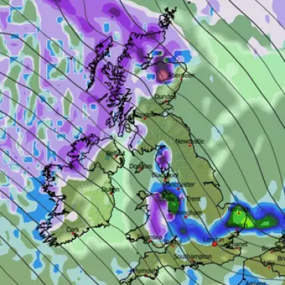
The United Kingdom is preparing for another round of severe wintry weather, with fresh meteorological data indicating significant snowfall could arrive within days.
Winter's Icy Grip Returns
Fresh weather charts from WXCharts are displaying ominous white and purple patches for November 30, signalling the potential for substantial snow accumulation across large portions of the country. This comes after parts of Scotland recently endured the coldest autumn evening in 15 years, with temperatures plummeting to a brutal -12.6°C.
Which Areas Will Be Affected?
The forecasting maps suggest several major urban centres could see snowfall, including Birmingham, Manchester, Bristol, Leeds, and Stoke-on-Trent. The Cotswolds are also in line for wintry conditions, with temperatures expected to crash to a biting -2°C in these regions.
However, the most extreme conditions are predicted for Scotland. Areas around Inverness and Aberdeen could experience a punishing -6°C, creating potentially hazardous travel conditions and the deepest cold of this upcoming spell.
Met Office Long-Range Outlook
The Met Office's forecast for November 27 to December 6 warns of a shift towards more unsettled conditions. A statement indicates that after a brief settled start, Atlantic weather systems will bring a change.
"Rain could at times be heavy and prolonged, with the risk of gales," the forecast states. It also mentions the possibility of short-lived settled periods, particularly in the south-east, which could bring an increased risk of frost and fog.
Despite the cold snap, the overall period is expected to be milder than recent conditions, with temperatures generally above average for the time of year as we move into early December.


