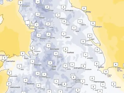
Snow is set to fall across parts of the North East on Tuesday, November 17, with a Met Office yellow warning in force for the region. The alert runs from midnight on Monday to midday on Tuesday, with forecasters warning of potential disruption on high ground.
According to the Met Office, a band of rain moving northwards across the UK through Monday night and Tuesday morning is expected to turn to snow as it meets colder air, mainly affecting locations at 100m altitude or higher. Snow falling below this level is likely to be temporary and melt quickly.
Snow depths and travel impact
Where snow does accumulate, depths of 1-5cm are likely, while some locations above 300-400m could see 5-15cm. The Met Office said: "This may cause travel disruption on higher level routes, particularly in combination with a strong easterly wind which could also cause some localised drifting. Some accretion of ice onto infrastructure such as power lines is also a possibility. Snow will gradually turn back to rain both from the south and through the morning on Tuesday."
In addition to the snowfall, the North East is expected to experience heavy downpours throughout Tuesday.
Counties in line for snow
Weather maps show that parts of County Durham and Northumberland are mainly in line for snow. The charts indicate snow, marked in white and grey, hits the North East at 3am on Tuesday, with the first areas affected being Middleton-in-Teesdale and Barnard Castle in County Durham.
The band of snow, up to 4mm/hour, then moves to other areas over the next two hours, including Stanhope, Bishop Auckland and Consett, as well as Haltwhistle in Northumberland. It starts to disappear from 5am onwards, while the whole North East is set to see heavy rainfall from the early hours and continuing throughout Tuesday.
Regional forecast
Monday is expected to be widely dry with sunny spells to start but feeling cold, with scattered North Sea showers spreading inland from mid-morning. Showers could turn wintry at times over hills, with a maximum temperature of 5C.
Monday night will see showers easing with frost developing in places, before persistent rain spreads northeastwards overnight, reaching all parts by Tuesday morning and falling as sleet or snow over high ground, with a minimum temperature of 0C. Tuesday will be a cloudy, cold and wet day with persistent rain and some strong winds, with sleet or snow continuing to fall on hills until late morning and a maximum temperature of 5C.
Wednesday to Friday will be changeable, with periods of rain on Wednesday, drier and brighter conditions on Thursday after early rain, and a largely dry Friday with a chance of showers. Temperatures will be below normal.