The Met Office has issued its latest verdict on whether Wales will see its first snowfall of the winter as forecasters warn of potential disruption across the UK. Temperatures have plummeted to below zero in recent days, marking a distinctly wintry turn.
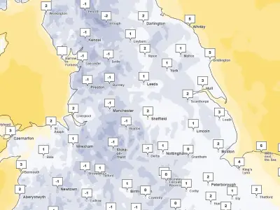
This sharp drop in temperatures means that a heavy band of rain moving over the UK at the start of this week could fall as snow instead. The wintry weather is expected to move in on Monday evening as a weather front blows in from the south-west, with some snow forecast to fall over hills in north Wales.
Yellow warning in place
The Met Office has issued a yellow warning for snow across a large part of the UK, in place from 12am to 12pm on Tuesday. The warning stretches from the West Midlands to southern Scotland.
Forecasters have said a band of rain is expected to head northwards across the UK through Monday night and Tuesday morning, which will likely turn to snow after it encounters colder air in the warning area.
Expected snow depths
Locations at 100-metre altitude or higher will mainly be affected, with any snow falling below this level likely to be temporary and quickly melting, the Met Office said. In areas where snow does accumulate, depths of 1-5cm are likely, with some locations above 300-400 metres potentially seeing 5-15 cm.
Met Office meteorologist Aidan McGivern said in an evening weather update on Sunday that there will be an “unsettled picture” on Tuesday. He said: “It’s during Monday evening that we’re likely to see some freezing rain or snow over upland parts of mid to north Wales, rain at lower levels, and then as that system moves into the colder air across northern England and southern Scotland during the early hours of Tuesday, we’re likely again to see some significant and disruptive snow above 300 metres for northern England, above about 150-200 metres for southern Scotland.”
He added: “That, accompanied by increasingly strong winds, we’re talking about 50-60 mph wind gusts, means that it is going to be hazardous for upland parts of northern England and southern Scotland, with the risk of drifting snow, ice accretion, and blizzards at lower levels.”
Winds and outlook
He said while there could be a little snow at lower levels, it will likely turn back to rain by the start of the day, adding: “And for where most people live, it will mostly be wet weather rather than wintry weather.”
To accompany the wintry weather on Monday evening, the Met Office says Wales could also see very strong winds. The forecast for Monday evening says: "Cloud and rain moves in from the southwest overnight, turning heavy, persistent and falling as snow over northern hills. Turning windy, with gales possible over hills and towards the coasts. Minimum temperature 0C."
It will be changeable for the rest of the week, with chilly conditions and further outbreaks of rain expected before it turns brighter on Friday. The cold weather looks set to continue for the rest of the month, meaning snowfall is likely over higher ground again.
The BBC forecast for Monday, November 23 to Sunday, November 29, says: "In late November the outlook is rather complex. While Atlantic low pressure circulations and associated fronts may still move across or near the UK, it's possible that they will take aim more at southern regions than the north. As a result, England and Wales might end up wetter overall than Scotland and Northern Ireland, although eastern Scotland may see more rain than the west due to occasional easterly winds."
It adds: "However, all areas of the UK should see at least a little rain or a few showers, some wintry over higher elevations, especially in Scotland. This set-up should mean that rather chilly air will hang on, with near to slightly below average temperatures across the northern half of the UK. There may be more variability across the south, with temperatures averaging out a shade above normal, and south-western regions of England will probably the mildest. The southern UK is also more likely to see occasionally fresh to strong winds than the north."