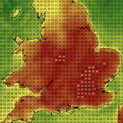
The United Kingdom is preparing for a dramatic shift in weather conditions this weekend, with forecasters predicting heavy rain and severe coastal gales that will bring an abrupt end to the recent spell of unseasonably warm and sunny weather. This comes after the country experienced one of its warmest April days on record earlier this week, creating a stark contrast in conditions.
Record-Breaking Warmth Gives Way to Unsettled Conditions
On Wednesday, April 8th, 2026, the UK basked in exceptional warmth, with temperatures soaring to 26.6°C at Kew Gardens in southwest London. This marked not only the hottest day of the year so far but also the second-hottest day ever recorded during the first half of April. The previous day, Tuesday, saw the warmest 7th of April on record in Mona, Anglesey, Wales, where temperatures reached 24.8°C.
Remarkably, these temperatures exceeded those in popular holiday destinations such as Ibiza and Rome, highlighting the unusual nature of this early spring heatwave. However, the warmth was short-lived, as cooler westerly winds from the Atlantic began to sweep across much of the country on Thursday, bringing temperatures back down to seasonal norms of 10-14°C.

Weekend Forecast: Rain and Strong Winds
The Met Office has issued warnings for the upcoming weekend, with conditions expected to turn increasingly unsettled. Friday will start with sunny spells for many areas, but rain and strengthening winds will spread into western regions later in the day. Temperatures are forecast to reach around 13°C in the southeast, with highs of 11°C across most of England.
Overnight into Saturday, coastal winds are predicted to intensify into gales, potentially reaching speeds of up to 54 mph on the east coast of Scotland. Rain will linger across central and eastern areas on Saturday morning, accompanied by strong winds nationwide throughout the afternoon. Heavy showers are expected to follow in Northern Ireland and western Scotland, with temperatures hovering around seasonal averages.
Mixed Conditions and Outlook
Sunday will bring a mix of sunny spells and showers across the country, with high winds particularly affecting western coastal areas. Temperatures are likely to settle around 13-14°C. Looking ahead to next week, after a cool start, temperatures are expected to climb slightly, though conditions will remain changeable.
Detailed Forecast Summary:
- Today: Dry start with sunny spells, but cloud will increase with rain spreading into western areas later. Strengthening winds and coastal gales, severe in the far northwest. Temperatures near average.
- Tonight: Rain in the west, locally heavy at first, moving eastwards. Clear spells and blustery showers follow in the west, turning chilly with possible rural frost as winds ease.
- Saturday: Rain across central and western areas, clearing eastwards. Showers follow, heavy in Northern Ireland and western Scotland. Windy with coastal gales in the west.
- Outlook for Sunday to Tuesday: Sunny spells with showers on Sunday, heavier further west. Monday sees more showers in lighter winds. Tuesday cloudier south with patchy rain, brighter elsewhere. Breezy at times, temperatures near normal.
Residents and travelers are advised to stay updated with the latest Met Office forecasts and prepare for potentially disruptive weather, especially in coastal regions where gale-force winds pose the greatest risk.