Met Office Forecasts UK Temperatures to Surpass Ibiza After Storm Dave
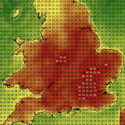
The Met Office has issued a dramatic weather forecast predicting that parts of the UK will experience temperatures hotter than Ibiza next week, following a turbulent Easter Bank Holiday weekend dominated by Storm Dave. According to the latest projections, London could see the mercury climb to a balmy 21°C on Wednesday, which would be several degrees warmer than the Spanish island's anticipated high of 18°C. This potential warm spell arrives in the wake of severe weather warnings for blizzard conditions and powerful winds across northern regions.
Storm Dave Brings Blizzards and Gale-Force Winds
Storm Dave is expected to form and rapidly intensify on Saturday as it approaches the UK from the west, bringing widespread disruption. The Met Office has issued yellow wind warnings effective from 5pm Saturday until 7am Sunday for North East England, North West England, South West Scotland, Lothian Borders, Strathclyde, Wales, and Yorkshire & Humber. Gusts of 50 to 60mph are forecast widely across these areas, with exposed locations potentially experiencing winds of 60 to 70mph.
In northern Scotland, heavy snowfall accompanying these strong winds is predicted to create blizzard conditions, with accumulations of 10-20cm possible on hills. Met Office deputy chief forecaster Tom Crabtree emphasised the severity, stating: "As well as strong winds, Storm Dave will also bring heavy snowfall over the hills in northern Scotland where up to 10-20cm of snow could accumulate. Along with the strong winds this will lead to blizzard conditions."

Crabtree advised the public to prepare their properties for the strong winds and stay updated with weather forecasts as warnings may be revised. The storm is expected to bring heavy spells of rain as it moves eastwards across the country, with cloudy conditions and outbreaks of rain spreading north during Saturday, becoming particularly persistent in the northwest.
Rapid Transition to Unseasonable Warmth
Following the storm's passage, a remarkable weather turnaround is anticipated. The Met Office forecasts highs of 18°C on Tuesday across multiple regions, with Manchester and Glasgow both expected to reach this temperature. Wednesday could see London peak at 21°C, which would surpass the current hottest day of the year recorded on March 18 in Gogerddan near Aberystwyth at 20.9°C.
This predicted warmth represents a significant contrast to the weekend's conditions. The outlook for Monday to Wednesday suggests a frosty start on Monday giving way to dry conditions with long sunny spells. Tuesday is expected to be similar though cloudier in the northwest with some rain, which will spread southeast on Wednesday as temperatures rise.
However, this warm interlude may be brief. By Thursday, temperatures are forecast to drop back to 14°C in London and 11°C in Manchester, indicating a return to more seasonal conditions. The Met Office's detailed forecast for Sunday predicts that cloud, rain and hill snow across the far northeast will clear as winds ease, with sunny spells and blustery showers for many, though southern areas may remain dry.
Tonight's conditions are expected to remain very windy with gales and potentially severe gales across parts of Northern Ireland, Scotland and northern England, accompanied by outbreaks of rain and snow over modest hills across Scotland. This dramatic weather pattern underscores the UK's variable spring climate, with extreme conditions giving way to unseasonable warmth within days.