
UK weather maps are forecasting a dramatic shift to warmer conditions this week, with five regions expected to hit a scorching 22C. This comes after the chaos unleashed by Storm Dave, which brought heavy rainfall, powerful winds, and even snow warnings across parts of the country.
From Storm to Scorcher: A Rapid Weather Change
The milder weather is predicted to arrive midweek, following a period of highly unsettled and disruptive conditions caused by Storm Dave. The storm has delivered gale-force winds and significant precipitation, leading to amber weather warnings in northern England, Scotland, and Wales.
How the Warm-Up Will Happen
A change in the jet stream later this week will allow high pressure to build from the south. As Storm Dave moves eastwards, warmer air from continental Europe will sweep into southern Britain. This meteorological shift will push temperatures up into the low 20s Celsius, providing a welcome and temporary respite from the recent stormy weather.

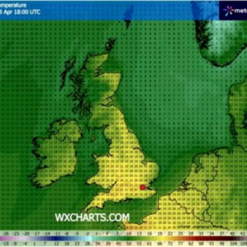
Detailed Temperature Forecast
According to WXCharts weather maps, which utilise MetDesk data, the peak of this warm spell will occur on Wednesday, April 8. Specific forecasts include:
Regions forecast to reach 22C:
- London
- Kent
- Essex
- East Sussex
- Thames Valley
Regions forecast to reach 21C:
- Midlands (both West and East Midlands)
- East Anglia (including Norfolk and Suffolk)
- Lincolnshire
- Gloucestershire
- South Wales
Furthermore, numerous other parts of the UK are expected to experience temperatures exceeding 20C during this period.
Timeline of the Warming Trend
Additional weather maps indicate that many areas will start to feel the change from Tuesday, with highs of up to 19C. The peak of the scorching temperatures is projected for Wednesday around 6pm, when the aforementioned regions are forecast to hit 22C.
The Storm Dave Aftermath
This warm interlude follows significant disruption from Storm Dave. The Met Office had issued warnings that the storm could deliver heavy snow and gale-force winds, particularly on Sunday. An amber weather warning for wind was implemented for areas of northern England, Scotland, and Wales, with the Met Office noting the storm would "continue to deepen."
Fierce blizzards and powerful winds have already caused havoc, with gusts of up to 66mph recorded in Capel Curig, north Wales. The affected areas under the amber warning included Lancashire, North Yorkshire, Northumberland, north Wales, and Scotland. A separate wind alert also remained active for northern England, parts of Scotland, and areas of Wales.
The forecasted 22C temperatures will therefore offer a stark and pleasant contrast to the recent turbulent weather patterns experienced across the United Kingdom.


