UK Braces for Dramatic Weather Shift: Balmy 20C Sunshine to Give Way to -6C Arctic Blast
Britons are being urged to savour a spell of unseasonably warm sunshine this week before a severe Arctic blast sweeps across the country, bringing temperatures as low as -6C and significant snowfall by the end of March. Weather maps from WXCharts and forecasts from the Met Office indicate a dramatic meteorological reversal is on the horizon.
Spring Sunshine and Record Warmth Expected This Week
A weekend cold snap is receding, making way for a period of notably mild weather as low-pressure systems move northwards. The UK will come under the influence of two high-pressure systems originating from southern and central Europe, setting the stage for the warmest conditions of the year so far.
Met Office maps project temperatures peaking at a remarkable 20C in western England and Wales on Wednesday, potentially surpassing the warmth of popular holiday destinations like Ibiza. Across England, temperatures could reach 18C quite widely, while Northern Ireland and Scotland will experience slightly cooler, yet still pleasant, conditions.

"Wednesday looks likely to be the warmest day of the week for many, with high pressure dominant," said Dan Harris, Chief Forecaster at the Met Office. "The warmest spots are likely to be in parts of west Wales and western England, where under sunny skies, 18-19C, possibly even 20C is on the cards."
Harris attributed the exceptional warmth in these regions to the Foehn effect, where east to south-easterly winds gain additional heat as they pass over higher ground. However, he also warned of a significant diurnal temperature range, leading to chilly nights and potential air frost following the warm days.
Severe Arctic Plunge and Snow Forecast for Late March
The spring respite will be short-lived. Forecasters warn that a series of low-pressure systems will sweep in towards the end of the month, ushering in cold polar air that will cause temperatures to plummet dramatically.
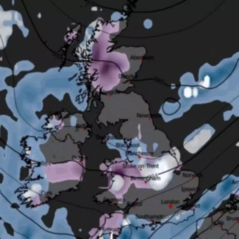
Weather models indicate the mercury could drop to -5C in Scotland and may even dip to -6C in parts of Wales. Elsewhere across the UK, temperatures are expected to hover near or below freezing. Accompanying this deep freeze will be substantial snowfall.
Maps from WXCharts show thick snow accumulating on March 30th, particularly affecting the Midlands, central Wales, and northern Wales. Flurries are also predicted for northern England and Scotland, painting a wintry picture for the final days of the month.
Met Office Outlook: Settled Start, Uncertain and Colder End
The Met Office's official forecast for March 21st to 30th suggests the period will begin with high pressure in charge, leading to predominantly dry conditions. Temperatures will be close to or slightly above average, although a brisk easterly wind may make parts of the south feel cooler than earlier in the week.
"Overall, with spells of spring sunshine, it should feel quite pleasant," the forecast states. However, it adds a note of caution: "How long the settled conditions last is less certain, with some signals that showers or rain could return later in the period, most likely to the south."
This aligns with the broader prediction of a sharp downturn. The message for the public is clear: enjoy the imminent burst of spring warmth, but do not pack away winter clothing just yet. The contrasting forecasts highlight the UK's volatile seasonal transition, where a taste of summer can swiftly be overtaken by a reminder of winter's bite.