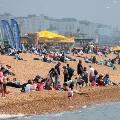
Britons can look forward to a warm late May bank holiday weekend, forecasters have said, following a bizarre day of hot sunshine, hailstorms, and heavy rain all within a few hours. Londoners shared videos of huge hailstones and intense downpours yesterday, which were followed minutes later by conditions suitable for sunbathing.
Recent Weather Extremes
Parts of the capital experienced their wettest day in two months after a prolonged dry spell, while nearly an inch (23.2mm) of rain fell in Greater Manchester. There was also a chill in the air, with temperatures below average for the time of year amid a brisk north-westerly wind and a UK high of just 15.8C (60.4F) in Dorset. However, while the mercury dropped to single figures in England and even to -0.4C (31.3F) in Aberdeenshire, forecasts suggest this may change by the May 25 bank holiday.
Met Office Forecast
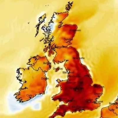
Met Office meteorologist Annie Shuttleworth said: "By the end of next week and the start of the bank holiday weekend, temperatures could be above average, possibly in the low 20s for some areas." The "warming trend" looks likely to progress as there is "going to be a move from low pressure to high pressure dominating" the weather. However, Ms Shuttleworth warned that "as that is ten days away, there are some details to work out." She noted there could be high pressure in the east to start the week, which then becomes more centred across the UK during the bank holiday weekend.

Temperature Rise Expected
Ms Shuttleworth added: "Whatever position that high pressure brings – all of them bring less cloud, a little bit more sunshine, and lighter winds, which means temperatures will be on the rise through next week." Temperatures may slowly start to rise from the start of next week. She said: "From Thursday onwards, temperatures could rise above average, approaching 20C for some across southern areas. We could be closer to the mid 20s, possibly, for some areas, in the South East, by the bank holiday weekend." There is "a little bit of uncertainty" about where the higher temperatures will be, she added.
Long Range Outlook
In its long range forecast covering May 18 to 27, the Met Office suggests that changeable conditions, including rain showers, look set to "dominate at first." It adds: "As this period progresses, high pressure is likely to begin to build from the south bringing more settled weather, although with occasional showers. Temperatures near-normal to begin, but tending to recover as the period progresses, perhaps becoming rather warm by the end of the period, especially in the south. Winds will be stronger during the first part of the period, generally from a south-westerly direction, before becoming lighter in line with the more settled conditions."
Current Conditions Explained
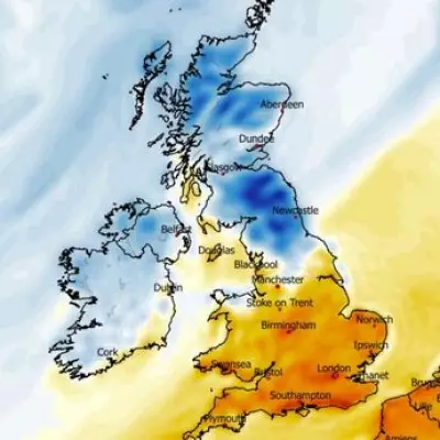
Looking back at the week so far, Met Office spokesman Stephen Dixon told the Daily Mail that the weather had "certainly been serving up a mixed picture in recent days, with sunshine, rain, winds and even hail thrown into the mix." He added: "When you add in the fact it has been cooler than average for much of the country, some people might be wondering what exactly is going on?" Mr Dixon explained that current conditions were "a relatively typical spell of spring weather, with a combination of factors leading to the mixed conditions people are experiencing." A cold northerly airflow is pulling temperatures below the average for the time of year – with low pressure generally to the east and higher pressure out to the west. The UK is seeing a continuation of this northerly airflow and a clash between periods of more showery weather, as well as some drier and sunnier interludes.

Mr Dixon said: "Some of those showers have also been developing into pockets of hail in places, something which we can see during this kind of set-up. This theme is likely to continue through the coming days and into the weekend, with a real mix of spring weather for much of the UK, including some sunnier spells, as well as some showers in places." However, looking ahead, he added: "By the start of next week, we start to see hints of a change from the South West, with things gradually getting warmer through the week, though this will be accompanied by some heavy rain through the start of next week in places. There's a chance of some drier and warmer weather further south by the end of next week, but there's still a lot of uncertainty in forecast so there's still plenty to play for as to how exactly this potential warmth takes shape and how widespread it might be."
Advice for Gardeners
Joe Whitehead, chairman of the Professional Gardeners' Guild, said May is the trickiest month and can be "so difficult" for gardeners. He said his advice is to "look at the weather every day so you've got an idea of what's coming up." Mr Whitehead added: "Anything tender, bring them in to the garage, to the porch, or cover them with something. In your allotment, think about your potatoes coming through the ground."
April Weather Summary
Met Office statistics for April showed that month was drier, warmer and sunnier than average across the country, although conditions varied by region. The UK saw its seventh warmest April on record and its fourth sunniest. Meteorological spring ends on May 31, from which meteorological summer will run until the end of August.