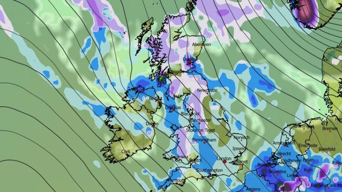
Advanced weather modelling maps are predicting a dramatic return to winter conditions across the United Kingdom, with significant snowfall expected to hit major cities within mere hours. Leading forecasters have issued stark warnings of a 'second winter' descending upon the nation, bringing with it plummeting temperatures and widespread disruption.
Imminent Snowfall Across the Nation
The latest data from the GFS weather model reveals that snow flurries could begin as early as 6am on Wednesday, initially targeting western parts of Northern Ireland, Wales, and north-west England. Simultaneously, more intense snowfall is forecast for Scotland, particularly in the far northern regions. As the day progresses, this wintry precipitation is expected to weaken but spread significantly.
Major Cities in the Firing Line
By mid-afternoon on Wednesday, weather maps indicate light snow could be falling in several prominent urban centres. Cities such as Stoke-on-Trent, Manchester, and Newcastle are all highlighted as potential recipients of this unexpected late-March snowfall. The data further suggests that parts of Devon in south-west England may also experience some snow accumulation.
Temperature Plunge Accompanies Snow
The arrival of snow will be accompanied by a dramatic drop in temperatures across the country. According to GFS modelling, the mercury could plummet to a frigid -4°C in Scotland by midday on Thursday. Northern England is forecast to experience temperatures around -3°C, while Wales, the Midlands, and some southern parts of England could see readings as low as -1°C.
Meteorologist Laura Tobin emphasised the severity of the situation during an appearance on Good Morning Britain, stating unequivocally that the UK is facing a 'second winter'. She explained that following the recent spring equinox, significant movements in the jet stream are once again directing cold air toward British shores. This development comes as a particular shock following last week, which delivered the warmest day of the year so far.
Official Forecast Confirms Wintry Outlook
The Met Office has corroborated these predictions, warning that snow is indeed likely to arrive on Wednesday. The national weather agency anticipates temperatures could drop to a bone-chilling -5°C overnight on Wednesday, particularly in rural parts of Scotland.
Their official forecast states: "By Wednesday, it will feel markedly colder across all parts, with rain, sleet and hail showers potentially quite widespread, and snow likely over higher ground in the north. Elsewhere, it will be a blustery day and although there is some sunshine on offer, it will feel cold thanks to the wind chill. Temperatures will fall overnight – potentially to -5°C in rural Scotland – with a widespread frost overnight likely for most, and ice at first in the north on Thursday morning."
The Met Office adds that while most areas should remain dry with sunny spells on Thursday, cloud and rain will push into Northern Ireland and western regions later in the day. Temperatures are expected to return closer to seasonal averages from Friday onward, though further unsettled weather systems may affect the UK over the weekend, most likely targeting northern areas.
This sudden return to wintry conditions serves as a stark reminder of the UK's unpredictable spring weather patterns, with advanced modelling suggesting that several major population centres could be dealing with snow accumulation within the next 24 hours.


